Various signs
The ultimate street signs, historical sites and house numbers
× Want to add signs? There is an app! Get it on Google Play Download on the App Store

Sign: Tel Aviv - Government House in Jaffa


Address:
Nehama St 10, Tel Aviv-Yafo, Israel
City:
Country:
Shape:
Material:
Placement:
Click here for a map that contains other items in the area

On the sign:
[סמל Palestine - High Commissioner
מפת האזור: DISTRICT SOUTHERN / SUB-DISTRICT JAFFA]

בית הממשל ביפו
במהלך שנות השלושים נבנו רוב המגרשים הפנויים בשכונה שהוקמה בשטח פרדס מוסתקים (השכונה הירועה כיום כשכונת נגה) בקצה הדרום-מזרחי של המתחם, סמוך לבתיה הקיצוניים של המושבה האמריקאית-גרמנית, בנתה משפחת קרסו באותו העשור בניין גדול החולש על בלוק שלם. מרחוב אבו אל-הודא (כיום רחוב פוריה) ועד רחוב נאחאס פאשה (כיום רחוב נחמה). קומת הקרקע של הבניין יועדה למוסכים ולמחסנים. שתי הקומות האחרות למשרדים. בניין זה שימש משנת 1936 ועד 1948 כבית הממשל כאן היתה לשכתו של מושל יפו, ומכאן נוהל מחוז הדרום המנדטורי. בשנות השלושים אירח הבניין גם את משרדי הטאבו. ספסרי קרקעות ורוכשי מגרשים נאלצו להגיע לכאן בימי מאורעות הדמים. לעיתים תוך סכנת נפשות. זאת עד פתיחת משרדי הטאבו בתל-אביב.

בשלהי מלחמת העולם השניה, עם החרפת מאבק המחתרות בבריטים, נכלל בניין הממשל, כמו גם בית טאנוס הסמוך לו, באזור בטחון שהקימו הבריטים. אזור זה הוקף בעמדות שמירה וגדרות תיל וכלל את רוב שטחה של המושבה האמריקאית-גרמנית, כולל בית מיכאקשווילי ברחוב אילת 14 ששימש את הבולשת הבריטית. אחרי קום המדינה עבר הבית לידי צה"ל ומערכת הביטחון ושימש פונקציות שונות. משרדי קישור שונים, האוגדה המרחבית האילתית (עוצבת אדום), מרכז גיוס של משמר הגבול, ועוד

קטע רחוב ניצנה הסמוך לבניין (בין רחובות נחמה לפוריה נכלל בשטח המחנה הצבאי והיה סגור לתנועת אזרחים). בתחילת האלף הנוכחי פינה הצבא את הבניין. בשנים 2009-2012 נבנה בסמוך פרוייקט הכפר (The Village) והקיר בקצה רחוב נחמה (בין בית הממשל לבית טאנוס) הפך לכניסה לחניון התת קרקעי של הפרויקט החדש, תוך ניצול הפרשי הגבהים בין רחוב נחמה ובין שטח הפרוייקט.

מאת דני רכט
Photography:
Add comments, corrections, or missing information. After clicking the "Submit" button you will be taken to a page where you will be required to specify your name and email address.
Please note, you do not need to specify details about the item, these details will be automatically added


Comments:
The building was photographed on the same day by the same photographer Click for a larger image

Translation of the text on the sign:
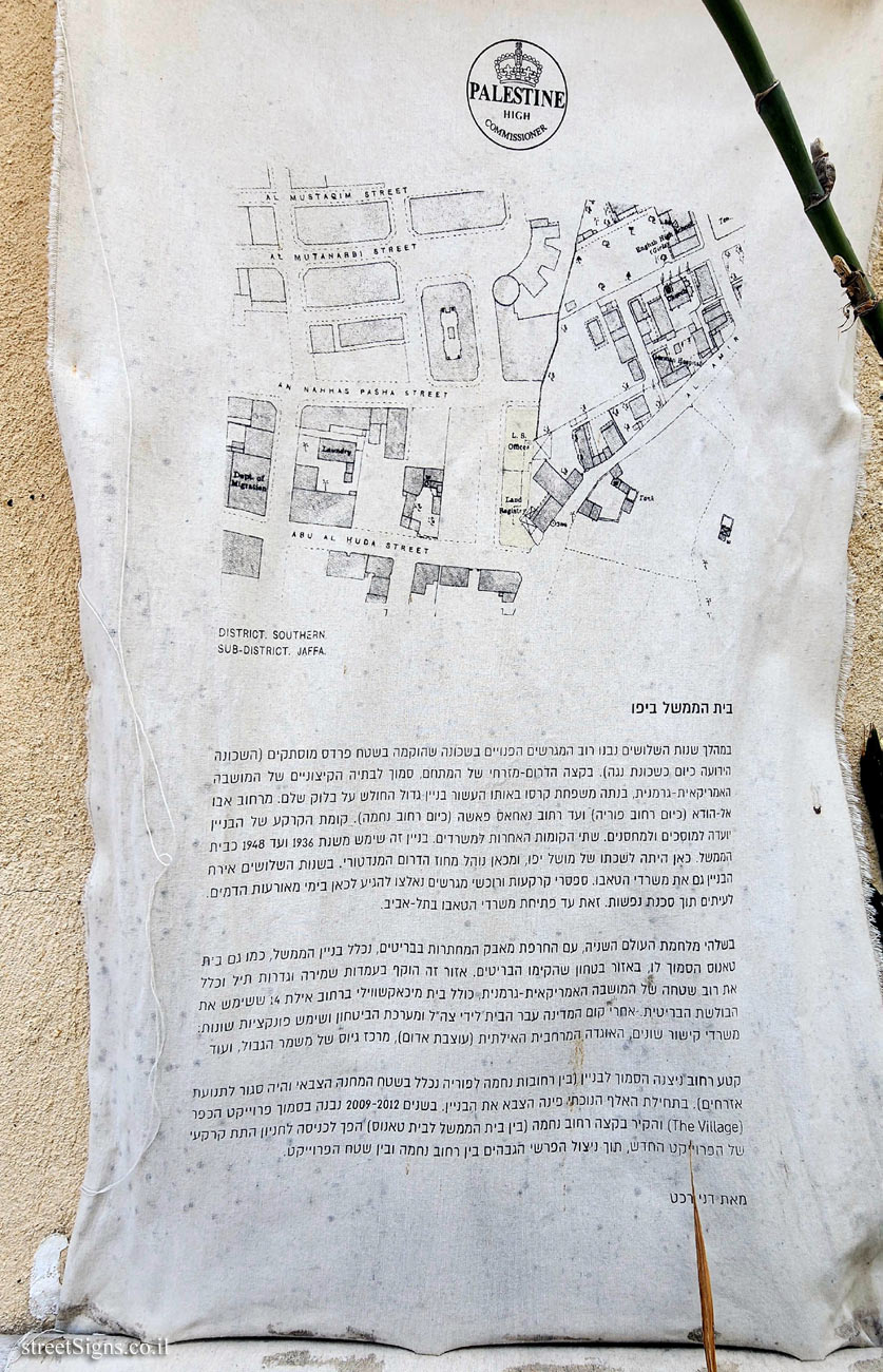
[Symbol Palestine - High Commissioner
Area map: DISTRICT SOUTHERN / SUB-DISTRICT JAFFA]

Government House in Jaffa
During the 1930s, most of the vacant lots were built in the neighborhood that was established in the area of Pardes Mustakim (the neighborhood that is now known as the Noga neighborhood). At the southeastern end of the complex, near the extreme houses of the American-German colony, the Karaso family built a large building that dominates an entire block in the same decade. From Abu Al-Huda Street (today Porya Street) to Nakhas Pasha Street (today Nachama Street). The ground floor of the building was designated for garages and warehouses. The other two floors are for offices. This building was used from 1936 to 1948 as the government house. Here was the office of the governor of Jaffa, and from here the Mandatory Southern District was administered. In the 1930s, the building also housed the Taboo offices (Land registration). Land brokers and land buyers had to come here during the bloody events. Sometimes at the risk of lives. This is until the opening of the Taboo offices in Tel Aviv.

At the end of World War II, with the worsening of the underground struggle against the British, the administration building, as well as the Tanos house next to it, was included in a security zone established by the British. This area was surrounded by guard posts and barbed wire fences and included most of the area of the American-German colony, including the Mikhakashvili house at 14 Eilat Street that was used by the British Bureau of Investigation. After the establishment of the state, the house passed into the hands of the IDF and the security establishment and served various functions.

The section of Nitsana Street adjacent to the building (between Nechama and Poriya streets was included in the area of the military camp and was closed to civilian traffic). At the beginning of the current millennium, the army evacuated the building. In the years 2009-2012, the village project (The Village) was built nearby and the wall at the end of Nechama Street (between the Government House and Tanos House) became the entrance to the underground parking lot of the new project, taking advantage of the height differences between Nechama Street and the project area.

by Danny Recht


The ultimate street signs, historical sites and house numbers

Initiating the site - Eli Zvuluny - Programming and building the site Possible Worlds Ltd. Possible Worlds Ltd. © 2019-2024

© ALL RIGHTS RESERVED - The site and its content are copyright protected. The full copyrights of the site's content belong to Eli Zvuluny. All images in the site (unless another photographer is mentioned) were taken by Eli Zvuluny that has the full copyrights on them. The use of any images or other materials included herein, in whole or part, for any purpose is expressly prohibited without the written permission of Eli Zvuluny. .