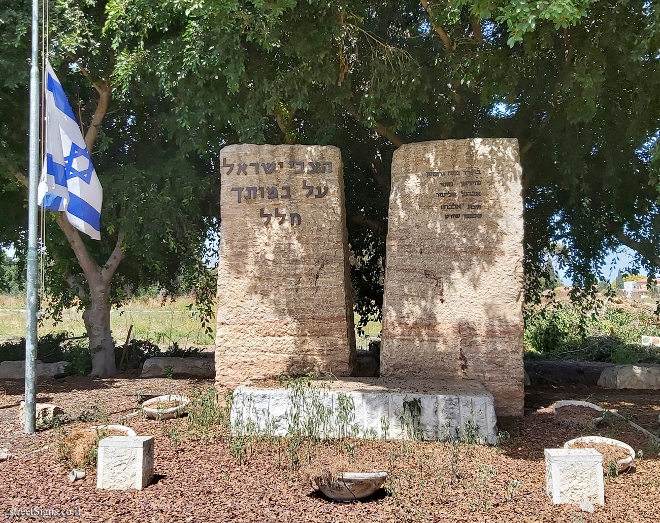
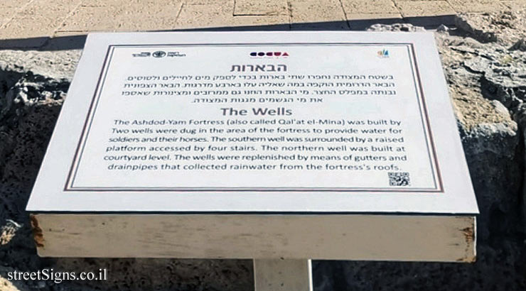
On the sign:
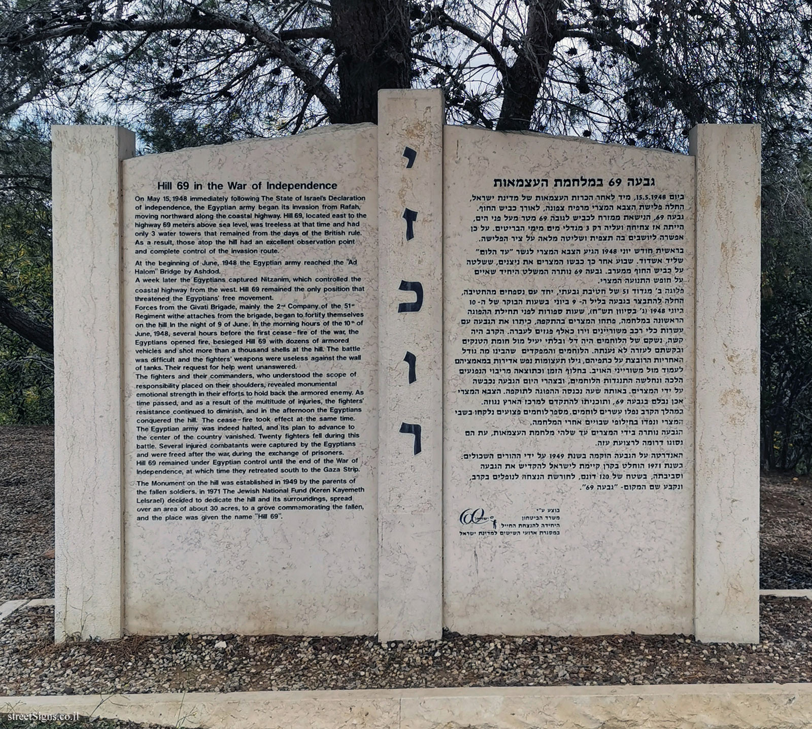
גבעה 69 במלחמת העצמאות
ביום 15.5.1948, מיד לאחר הכרזת העצמאות של מדינת ישראל, החלה פלישת הצבא המצרי מרפיח צפונה, לאורך כביש החוף. גבעה 69, הנישאת ממזרח לכביש לגובה 6 מטר מעל פני הים, הייתה אז צחיחה ועליה רק 3 מגדלי מים מימי הבריטים. על כן אפשרה ליושבים בה תצפית ושליטה מלאה על ציר הפלישה.
בראשית חודש יוני 1948 הגיע הצבא המצרי לגשר "עד הלום" שליד אשדוד. שבוע אחר כך כבשו המצרים את ניצנים, ששלטה על כביש החוף ממערב. גבעת 69 נותרה המשלט היחיד שאיים על חופש התנועה המצרי.
פלוגה ב’ מגדוד 51 של חטיבת גבעתי, יחד עם נספחים מהחטיבה, החלה להתבצר בגבעה בליל ה- 9 ביוני. בשעות הבוקר של ה- 10 ביוני 1948 (ג’ בסיוון תש"ח), שעות ספורות לפני תחילת ההפוגה הראשונה במלחמה, פתחו המצרים בהתקפה, כיתרו את הגבעה עם עשרות כלי רכב משוריינים וירו כאלף פגזים לעברה. הקרב היה קשה, נשקם של הלוחמים היה דל ובלתי יעיל מול חומת הטנקים ובקשתם לעזרה לא נענתה. הלוחמים והמפקדים שהבינו מה גודל האחריות הרובצת על כתפיהם, גילו תעצומות נפש אדירות במאמציהם לעמוד מול משורייני האויב. בחלוף הזמן וכתוצאה מריבוי הנפגעים הלכה ונחלשה התנגדות הלוחמים, ובצהרי היום הגבעה נכבשה על ידי המצרים. באותה שעה נכנסה ההפוגה לתוקפה. הצבא המצרי אכן נבלם בגבעה 69, ותוכניתו להתקדם למרכז הארץ נגוזה.
במהלך הקרב נפלו עשרים לוחמים. מספר לוחמים פצועים נלקחו בשבי המצרי ונפדו בחילופי שבויים אחרי המלחמה.
הגבעה נותרה בידי המצרים עד שלהי מלחמת העצמאות, עת הם נסוגו דרומה לרצועת עזה.
האנדרטה על הגבעה הוקמה בשנת 1949 על ידי ההורים השכולים. בשנת 1971 הוחלט בקרן קיימת לישראל להקדיש את הגבעה וסביבתה, בשטח של 20 דונם, לחורשת הנצחה לנופלים בקרב, ונקבע שם המקום - "גבעה 69".
בוצע ע"י משרד הביטחון
היחידה להנצחת החייל במסגרת ארועי השישים למדינת ישראל
יזכור
Yizkor
Hill 69 in the War of Independence
On May 15, 1948 Immediately following The State of Israel’s Declaration of Independence, the Egyptian army began its Invasion from Rafah, moving northward along the coastal highway. Hill 69, located east to the highway 69 meters above sea level, was treeless at that time and had only 3 water towers that remained from the days of the British rule. As a result, those atop the hill had an excellent observation point and complete control of the invasion route.
At the beginning of June, 1948 the Egyptian army reached the "Ad Halom" Bridge by Ashdod.
A week later the Egyptians captured Nitzanim, which controlled the coastal highway from the west. Hill 69 remained the only position that threatened the Egyptians’ free movement.
Forces from the Givati Brigade, mainly the 2nd Company of the 51st Regiment with attaches from the brigade, began to fortify themselves on the hill in the night of 9 of June. In the morning hours of the 10th of June, 1948, several hours before the first cease-fire of the war, the Egyptians opened fire, besieged Hill 69 with dozens of armored vehicles and shot more than a thousand shells at the hill. The battle was difficult and the fighters’ weapons were useless against the wall of tanks. Their request for help went unanswered.
The fighters and their commanders, who understood the scope of responsibility placed on their shoulders, revealed monumental emotional strength in their efforts to hold back the armored enemy. As time passed, and as a result of the multitude of injuries, the fighters’ resistance continued to diminish, and in the afternoon the Egyptians conquered the hill. The cease-fire took effect at the same time. The Egyptian army was indeed halted, and its plan to advance to the center of the country vanished. Twenty fighters fell during this battle. Several injured combatants were captured by the Egyptians and were freed after the war, during the exchange of prisoners.
Hill 69 remained under Egyptian control until the end of the War of Independence, at which time they retreated south to the Gaza Strip.
The Monument on the hill was established in 1949 by the parents of the fallen soldiers. in 1971 The Jewish National Fund (Keren Kayemeth Lelsrael) decided to dedicate the hill and its surroundings, spread over an area of about 30 acres, to a grove commemorating the fallen, and the place was given the name "Hill 69".


 Click for sign's details