Various signs
The ultimate street signs, historical sites and house numbers
× Want to add signs? There is an app! Get it on Google Play Download on the App Store

Sign: Chania - excavations of the city from the Minoan period


Address:
Katre 10, Chania 731 32, Greece
Country:
Shape:
Material:
Placement:
Click here for a map that contains other items in the area

On the sign:
ΜINΩΙΚΗ ΚΥΔΩΝΙΑ
Η σύγχρονη πόλη των Χανίων είναι ίδρυμένη πάνω στη μινωική πόλη που τουλάχιστον από τον 14ο αι. π.Χ. θεωρείται ότι ονομαζόταν Κυδωνία ή κu-do-ni-ja σε κνωσιακές πινακίδες της Γραμμικής Β γραφής Κατά την παράδοση ήταν μία από τις τρεις κύριες πόλεις που ίδρυσε ο Μίνως στην Κρήτη (Κνωσός , Φαιστός, Κυδωνία) : Διόδωρος Σικέλιωτης V, 78.2.
Οι ανασκαφές των τελευταίων σαράντα χρόνων έχουν φέρει στο φως σημαντικα λείψανα του μινωικού οικισμού στο λόφο Καστέλλι και στη γειτονική συνοικία Σπλάντζια, στην Παλιά Πόλη. Τα αρχαιολογικά ευρήματα στις παραπάνω θέσεις αντιπροσωπεύουν όλες τις αρχαιολογιχές φάσεις του μινωικού πολιτισμού, από την πραuiνωική Ι (3650 π.Χ.) έως την μστερομνωική III Γ (1200 π.Χ.) περίοδο.
Η νεοανακτορική περίοδος (1600 - 1450 π.Χ.) όπως και η κρητομυκηναική η μετανακτορική ( 1400-1100 π.Χ.), είναι έως σήμερα oι πιο γνωστές και καλύτερα συζόμενες φάσεις του μινωικού. πολιτισμού στα Χανιά. Η νεοανακτορική εγκατάσταση των Χανίων κατατάσσεται στα ανακτορικά κέντρα με προσεγμένο πολεοδομικό σχέδιο, συγκεντρωτική εξουσία και γραφειοκρατική οργάνωση. Την τελευταία περίοδο του μινωικού πολιτισμού, που η Κρήτη αποτελεί πλέον Τμήμα του μυκηναϊκού κόσμου , η Κυδωνία παρουσιάζει εντυπωσιακή ευημερία και αποτελεί το κομβικό σημείο ενός υπερπόντιου εμπορικού δικτύου , με επαφές στην ηπειρωτική Ελλάδα, τις Κυκλάδες, την Κύπρο, τη Χαναάν , τη Συρία, την Αίγυπτο την Ιταλία και τη Σαρδηνία.
Το οικόπεδο ιδιοκτησίας Βακαλουνάκη ανασκάφτηκε τα έτη 1973--1975, και έφερε στο φως τμήμα του αρχείου της μινωικής Κυδωνίας (Εικ 1).
Στη δυπκή πλευρά του οικοπέδου και στα ανωτερα στρματά εντοπίστηκαν υπολείμματα κτίρου και λιθόστρωτου της γεωμετρικής περιοδου. Στην ανατολική πλευρά τα αποσπασματικά Λειψανα μινωικν κατασκεύων που βρέθηκαν στα ανωτερα στρματα Χρονολογήθηκαν στην ΥΜ ΙΙΙ Β (1300-1200 π.Χ) και ΥM ΙΙΙ Γ (1200-1100 π.Χ) περίοδο Βαθύτερα αποκαλύφθηκαν τα λείψανα δύο κτιρίων ( κτίρια Ι-ΙΙ ) , που φαίνεται ότι καταστράφηκαν από τη μεγάλη πυρκαγιά του 1450 π.Χ. , η οποία εντοπίζεται και στα υπόλοιπα κρητικά κέντρα εκτός του ανακτόρου της Κνωσού . Στο δάπεδο του ενός κτιρίου, βρέθηκε στρμα με έντονο κόκκινο χρμα, από το Ψήσιμο των διαλυμένων ωμν πλίνθων, που περιείχε επίσης μικρά κομμάτια καμένου ξύλου, μικρές καμένες ελαφρόπετρες , θραύσματα έγχρωμων ασβεστολιθικν αλλά και πήλινων κονιαμάτων Μέσα σε αυτό το στρμα καταστροφής βρέθηκαν κατάλοιπα του αρχείου της μινωικής Κυδωνίας: 72 θραύσματα πνακίδων ( Εικ. 8 ) , 104 δισκία (Εικ. 7 ) , 28 πολυεδρικά και 58 απλά σφραγίσματα. Ο πινακίδες έχουν κείμενα στη Γραμμική Α γραφή. Σημεία ή ιδεογράμματα της ίδιας γραφής έχουν χαραχθεί στη μία επιφάνεια των δισκίων και σε μία ή δύο όψεις των πολυεδρικν σφραγισμάτων . Τα δισκία φέρουν πολλαπλά αποτυπματα από την ίδια πάντα σφραγίδα στην περιφέρεια τους και τα πολυεδρικά σφραγίσματα σε μία από τις τρεις μακριές όψεις τους. Τα απλά σφραγίσματα έχουν κυρίως ένα αποτύπωμα και είναι ανεπίγραφα (Εικ . 5-6) . Τα αντικείμενα του αρχείου δεν βρέθηκαν στη θέση τους πάνω στο δάπεδο Φαίνεται ότι είτε κατέπεσαν από τον όροφο ή προέρχονται από κτίριο που βρισκόταν βορειότερα, σε ψηλότερο επίπεδο
Λείψανα ενός τρίτου κτιρίου ( κτίριο III) , που χρονολογείταί στην ΜM II -YM I περίοδο ( περ. 1700- 1600 π.Χ ) , εντοπίστηκαν στη δυτική πλευρά του χρου φαίνεται ότι και τα τρία κτίρια επισκευάσθηκαν μετά την καταστροφική πυρκαγιά της ΥΜIB περιοδου (1480-1425 π.Χ. ) και συνέχισαν να λειτουργούν έως και την ΥM III ΑI περίοδο (1400-1370 π.Χ.).
Σε τομή βαθύτερα των κτιρίν αποκαλύφθηκε λιθόστρωτο , πιθανόν υπαίθριου χρου , της ΜM III περιόδου. Το λιθόστρωτο κατασκευάστηκε πάνω στα λείψανα πρωιμότερου κτιρίου της ΜM I-II περιόδου (2160-1700 π.Χ. ) που σζει υπολείμματα τοίχων και πλακόστρωτου .

[Images]
Τοπογραφικό σχέδιο πόλης Χανίων. Θέσεις επισκέψιμαν αρχαιολογικν χρων.
Εικ. 1: Γενική άποψη ανασκαφικού χρου
Εικ. 2:Αμφορέας και . λεκάνη από την ανασκαφή
Εικ. 3: Εφυραϊκή κύληκα ΥΜII περιόδου.
Εικ . 4: Αρτόσχημο αλάβαστρο
Eικ 5 Σφράγιαμα με παράσταση καθιστής γυναικείας θεότητας που τρέφε αγρίμι.
Εικ. 6:Σφράγισμα με φυτική σύνθεση ("μάσκα λιονταριού" ).
Εικ 7. Πήλινα δισκία με ιδεογράμματα της Γραμμικής Α γραφής
Εικ. 8: Πήλινες πτνακίδες με κείμενα ης Γραμμκής Α γραφής
Photography:
Add comments, corrections, or missing information. After clicking the "Submit" button you will be taken to a page where you will be required to specify your name and email address.
Please note, you do not need to specify details about the item, these details will be automatically added


Comments:
The excavation site was photographed that day Click for a larger image

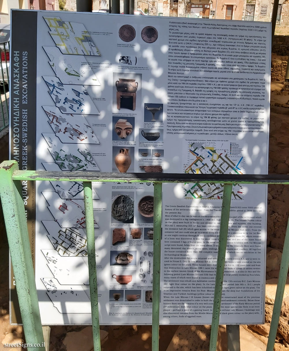
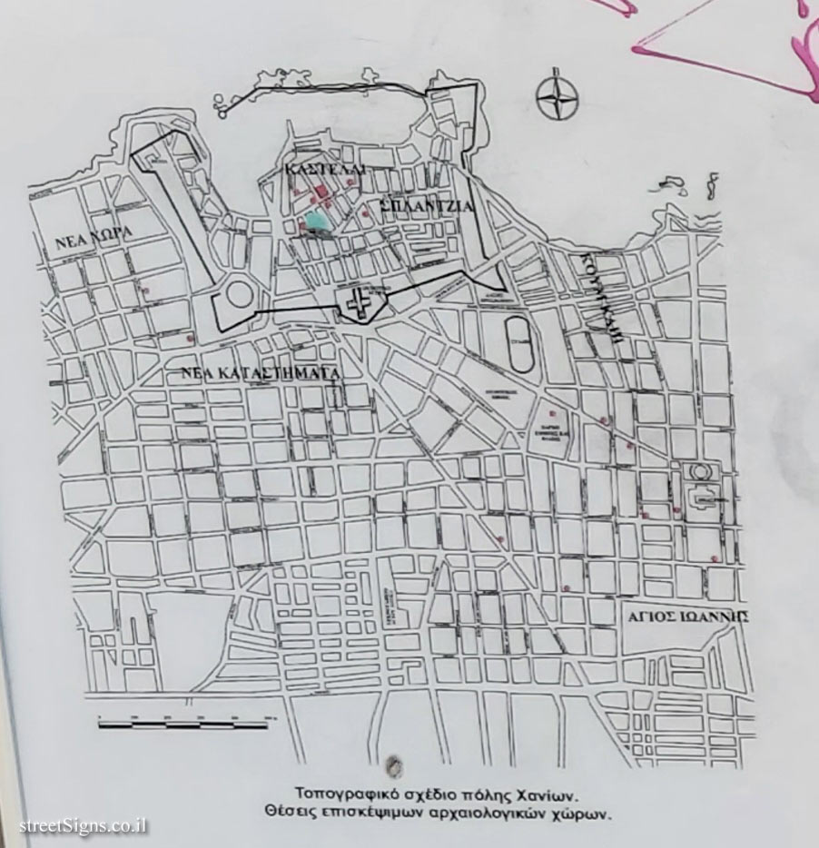
[The pictures on the sign:
Topographic plan of the city of Chania. Places to visit archeological sites. Click for a larger image
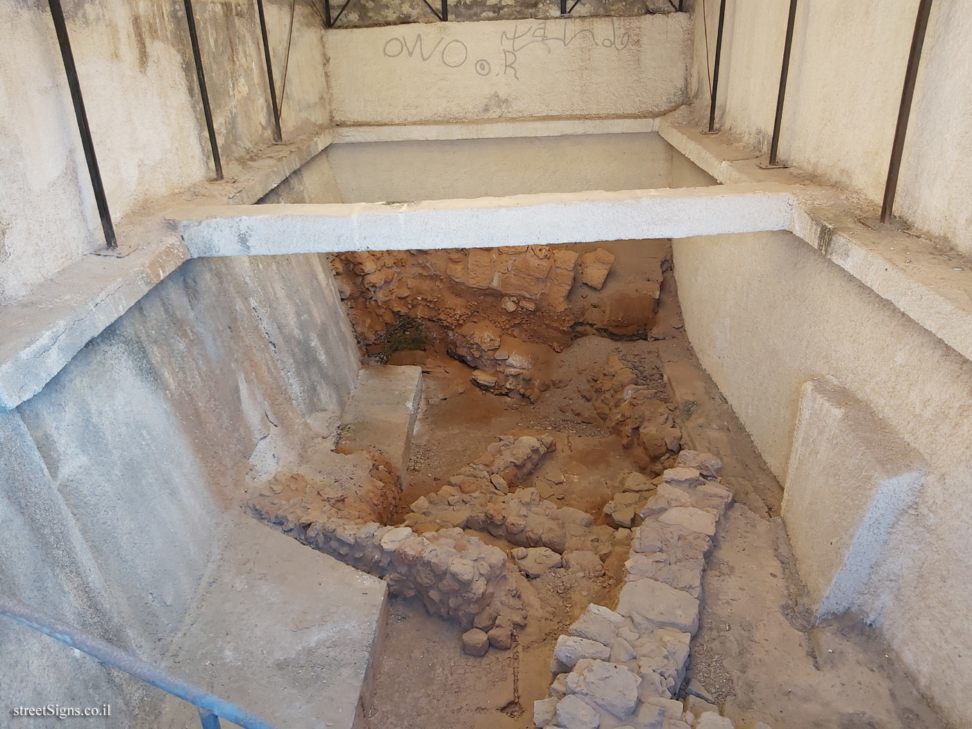
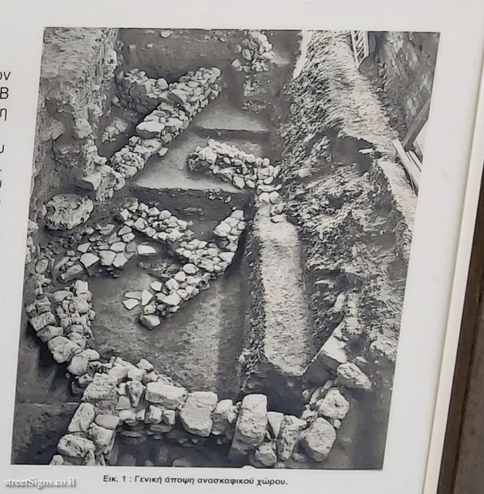
Fig. 1: General view of the excavation site Click for a larger image
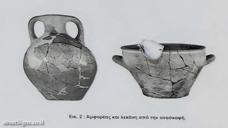
Fig. 2: Amphora and basin from the excavation Click for a larger image
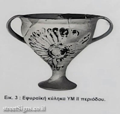
Fig. 3: Round cup YMII period Click for a larger image
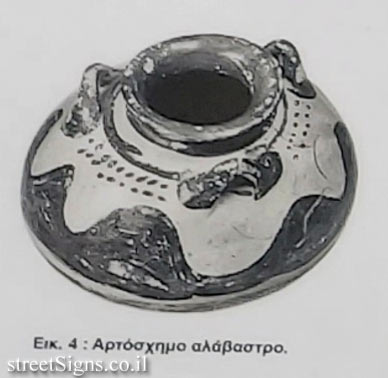
Fig. 4: Bread-shaped alabaster Click for a larger image
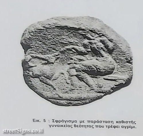
Fig. 5 Sealing with a representation of a seated female deity feeding wild. Click for a larger image
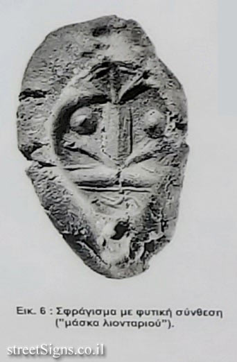
Fig. 6: Sealing with herbal composition ("lion mask"). Click for a larger image
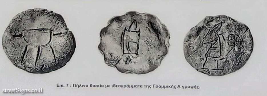
Fig. 7. Clay tablets with ideograms of Linear A writing Click for a larger image
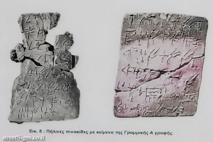
Fig. 8: Clay tablets with texts of Linear A writing Click for a larger image

Translation of the text on the sign:
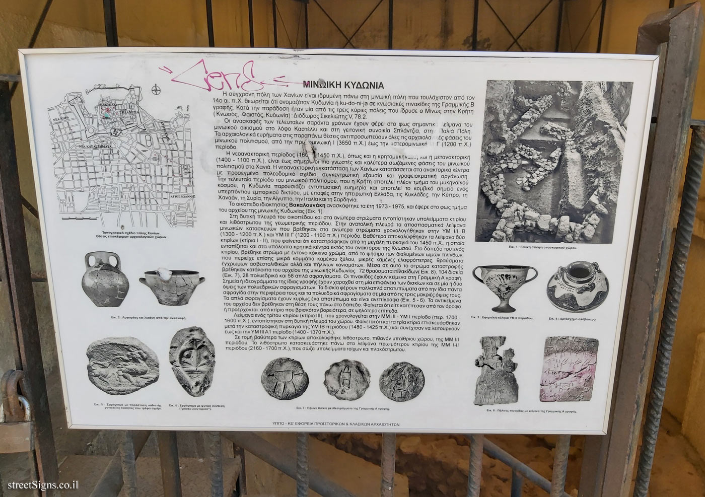
Minoan Kydonia
The modern city of Chania is founded on the Minoan city that at least from the 14th c. e.g. It is considered that it was called Kydonia or ku-do-ni-ja in Knossian tablets of the Linear B script. According to tradition, it was one of the three main cities founded by Minos in Crete (Knossos, Phaistos, Kydonia): Diodorus Sikeliotis V, 78.2.
The excavations of the last forty years have brought to light important remains of the Minoan settlement on the hill of Kastelli and in the neighboring district of Splantzia, in the Old Town. The archeological findings in the above places represent all the archeological phases of the Minoan civilization, from the pre-Ionian period (3650 BC) to the Late III III (1200 BC) period.
The neo-palace period (1600 - 1450 BC) as well as the Cretaceous-Mycenaean post-palace period (1400-1100 BC), are to this day the best known and best combined phases of the Minoan. of Culture in Chania. The neo-palace installation of Chania is classified in the palace centers with a careful urban plan, centralized power and bureaucratic organization. In the last period of Minoan civilization, when Crete is now part of the Mycenaean world, Kydonia presents impressive prosperity and is the focal point of an overseas trade network, with contacts in mainland Greece, the Cyclades, Cyprus, Canaan, Syria, Egypt, Italy and Sardinia.

The property plot Vakalounaki was excavated in the years 1973--1975, and brought to light part of the archive of Minoan Kydonia (Fig. 1 Click for a larger image).
Remains of a building and paving of the geometric period were found on the flat side of the plot and in the upper acres. On the east side are the fragmentary remains of Minoan structures found in the upper acres. Dated to YM III B (1300-1200 BC) and YM III C (1200-1100 BC) period. ), which seem to have been destroyed by the great fire of 1450 BC. , which is located in other Cretan centers outside the palace of Knossos. On the floor of a building, an acre was found with bright red paint, from the Baking of the dismantled ohm bricks, which also contained small pieces of burnt wood, small burnt pumice, fragments of colored limestone and clay mortars. of Minoan Kydonia: 72 fragments of tablets (Fig. 8 Click for a larger image), 104 tablets (Fig. 7 Click for a larger image), 28 polyhedral and 58 simple seals. The signs have texts in Linear A writing. Dots or ideograms of the same writing are engraved on one surface of the tablets and on one or two sides of the polyhedral seals. The tablets bear multiple imprints of the same seal on their periphery and polyhedral seals on one of their three long faces. The simple seals have mainly an imprint and are unwritten (Fig. 5 Click for a larger image - 6 Click for a larger image). The objects in the archive were not found in their place on the floor. It seems that they either fell from the floor or came from a building that was further north, at a higher level.
Remains of a third building (building III), dating to the MM II -YM I period (ca. 1700-1600 BC), were found on the west side of the site. It seems that all three buildings were repaired after the catastrophic fire of the YMIB period ( 1480-1425 BC) and continued to operate until the YM III AI period (1400-1370 BC).
In a deeper section of the buildings, a cobblestone, probably of outdoor color, of the MM III period was discovered. The paving stone was built on the remains of an earlier building of the MM I-II period (2160-1700 BC) that contains remains of walls and paving.

Learn about:


The ultimate street signs, historical sites and house numbers

Initiating the site - Eli Zvuluny - Programming and building the site Possible Worlds Ltd. Possible Worlds Ltd. © 2019-2024

© ALL RIGHTS RESERVED - The site and its content are copyright protected. The full copyrights of the site's content belong to Eli Zvuluny. All images in the site (unless another photographer is mentioned) were taken by Eli Zvuluny that has the full copyrights on them. The use of any images or other materials included herein, in whole or part, for any purpose is expressly prohibited without the written permission of Eli Zvuluny. .