On the sign:
ברוכים הבאים לפארק אריאל שרון
הפארק המטרופוליני של ישראל
פארק אריאל שרון הוא אחד מהמיזמים הגדולים בעולם בתחום השיקום הסביבתי, וייחודו בהפיכת תא שטח שזוהם בחלקו לפארק מטרופוליני. הפארק הוא ריאה ירוקה בלב האזור העירוני הצפוף בישראל, והוא פתוח לרווחת הציבור לפעילויות מגוונות של פנאי ונופש, טבע עירוני, חינוך ותרבות.
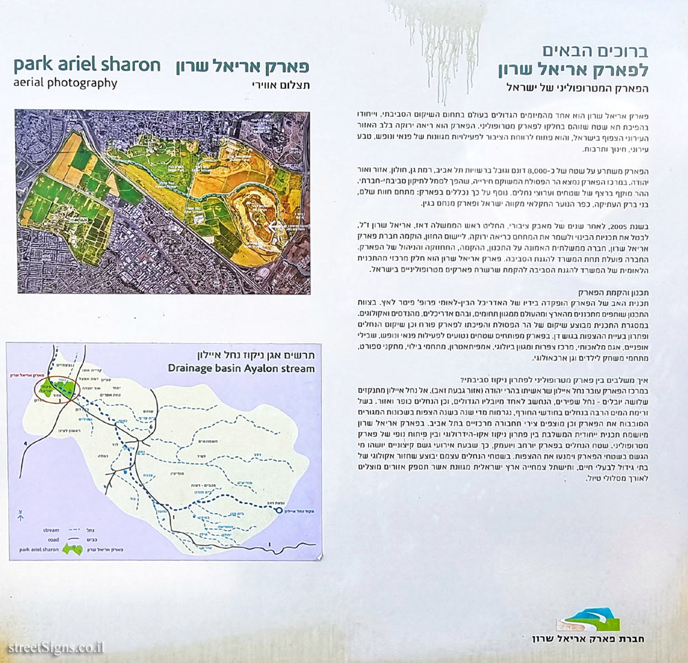
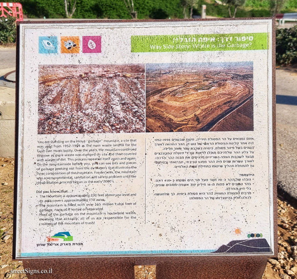
הפארק משתרע על שטח של כ-8,000 דונם וגובל ברשויות תל אביב, רמת גן, חולון, אזור ואור יהודה. במרכז הפארק נמצא הר הפסולת המשוקם חירייה, שהפך לסמל לתיקון סביבתי-חברתי. ההר מוקף ברצף של שטחים וערוצי נחלים. נוסף על כך נכללים בפארק: מתחם חוות שלם, בני ברק העתיקה, כפר הנוער החקלאי מקווה ישראל ופארק מנחם בגין.
בשנת 2005, לאחר שנים של מאבק ציבורי החליט ראש הממשלה דאז, אריאל שרון ז"ל, לבטל את תכניות הבינוי ולשמר את המתחם בריאה ירוקה. ליישום החזון, הוקמה חברת פארק אריאל שרון, חברה ממשלתית האמונה על התכנון, ההקמה, התחזוקה והניהול של הפארק. החברה פועלת תחת המשרד להגנת הסביבה. פארק אריאל שרון הוא חלק מרכזי מהתכנית הלאומית של המשרד להגנת הסביבה להקמת שרשרת פארקים מטרופוליניים בישראל.
תכנון והקמת הפארק
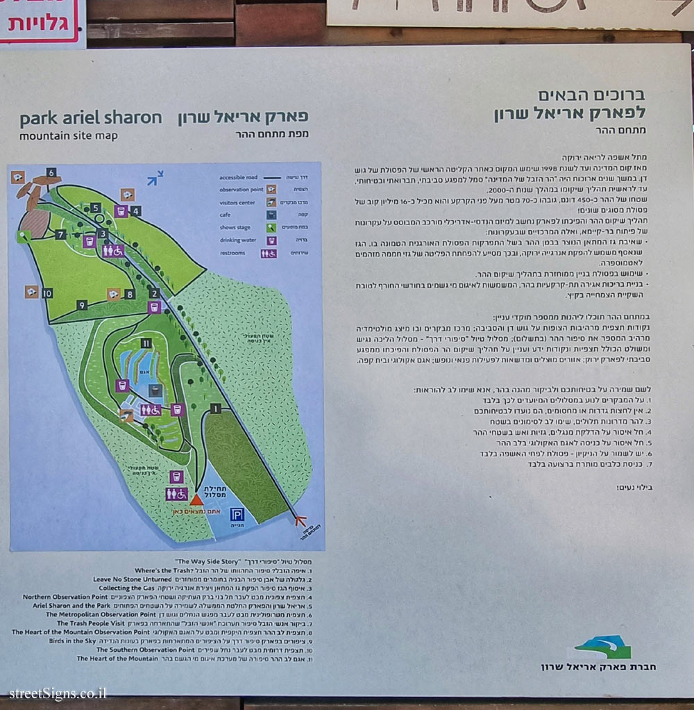
תכנית האב של הפארק הופקדה בידיו של האדריכל הבין-לאומי פרופ’ פיטר לאץ. בצוות התכנון שותפים מתכננים מהארץ ומהעולם ממגוון תחומים, ובהם אדריכלים, מהנדסים ואקולוגים. במסגרת התכנית מבוצע שיקום של הר הפסולת והפיכתו לפארק פורח וכן שיקום הנחלים ופתרון בעיית ההצפות בגוש דן. בפארק מפותחים שטחים נטועים לפעילות פנאי ונופש, שבילי אופניים, אגם מלאכותי, מרכז צפרות ומגוון ביולוגי, אמפיתאטרון. מתחמי בילוי, מתקני ספורט, מתחמי משחק לילדים וגן ארכאולוגי.
איך משלבים בין פארק מטרופוליני לפתרון ניקוז סביבתי?
במרכז הפארק עובר נחל איילון שראשיתו בהרי יהודה (אזור גבעת זאב). אל נחל איילון מתנקזים שלושה יובלים - נחל שפירים, הנחשב לאחד מיובליו הגדולים, וכן הנחלים כופר ואזור. בשל זרימת המים הרבה בנחלים בחודשי החורף, נגרמות מדי שנה בשנה הצפות בשכונות המגורים הסובבות את הפארק וכן מוצפים צירי תחבורה מרכזיים בתל אביב. בפארק אריאל שרון מיושמת תכנית ייחודית המשלבת בין פתרון ניקוז אקו-הידרולוגי ובין פיתוח נופי של פארק מטרופוליני. שטח הנחלים בפארק יורחב ויועמק, כך שבעת אירועי גשם קיצוניים יושהו מי הגשם בשטחי הפארק וימנעו את ההצפות. בשטחי הנחלים עצמם יבוצע שחזור אקולוגי של בתי גידול לבעלי חיים, ותישתל צמחייה ארץ ישראלית מגוונת אשר תספק אזורים מוצלים לאורך מסלולי טיול.
תצלום אווירי
aerial photography
תרשים אגן ניקוז נחל איילון
Drainage basin Ayalon stream
סמל חברת פארק אריאל שרון
Comments:
Translation of the text on the sign:
Welcome to Ariel Sharon Park
Israel’s Metropolitan Park
Ariel Sharon Park is one of the largest projects in the world in the field of environmental rehabilitation, and its uniqueness is the transformation of a contaminated area into a metropolitan park. The park is a green lung in the heart of the densely populated urban area in Israel, and is open to the public for a variety of activities of leisure and recreation, urban nature, education and culture.
The park covers an area of about 8,000 dunams and borders the authorities of Tel Aviv, Ramat Gan, Holon, Azor and Or Yehuda. In the center of the park is the restored Hiriya waste mountain, which has become a symbol of environmental-social repair. The mountain is surrounded by a sequence of areas and river channels. In addition, the park includes: the Shalem Farm complex, Old Bnei Brak, the Mikve Israel agricultural youth village and Menachem Begin Park.
In 2005, after years of public struggle, the then Prime Minister, the late Ariel Sharon, decided to cancel the construction plans and preserve the complex green healthy. The company operates under the Ministry of Environmental Protection. Ariel Sharon Park is a key part of the Ministry of Environmental Protection’s national plan to establish a chain of metropolitan parks in Israel.
Planning and construction of the park
The master plan of the park was entrusted to the international architect Prof. Peter Latz. The planning team includes planning partners from Israel and the world from a variety of fields, including architects, engineers and ecologists. As part of the plan, the waste mountain is being rehabilitated and turned into a flowering park, as well as the restoration of the streams and the solution of the flooding problem in Gush Dan. The park is developed planted areas for leisure and recreational activities, bike paths, an artificial lake, a birding center and biodiversity, an amphitheater. Recreation complexes, sports facilities, children’s play complexes and an archeological kindergarten.
How do you combine a metropolitan park with an environmental drainage solution?
In the center of the park runs the Ayalon River, which originates in the Judean Mountains (Givat Zeev area). Three tributaries drain into the Ayalon River - Nahal Shafirim, which is considered one of its largest tributaries, as well as the Kofar and Azor streams. Due to the large flow of water in the streams during the winter months, floods are caused every year in the residential neighborhoods surrounding the park and major transportation routes in Tel Aviv are flooded. In Ariel Sharon Park, a unique program is implemented that combines an eco-hydrological drainage solution with a landscape development of a metropolitan park. The area of the streams in the park will be widened and deepened, so that in the event of extreme rainfall events, rainwater will be suspended in the park areas and prevent flooding. In the areas of the streams themselves, an ecological restoration of animal habitats will be carried out, and diverse Eretz Israel vegetation will be planted, which will provide shaded areas along hiking trails.
aerial photography
Drainage basin Ayalon stream
Emblem of the Ariel Sharon Park Company