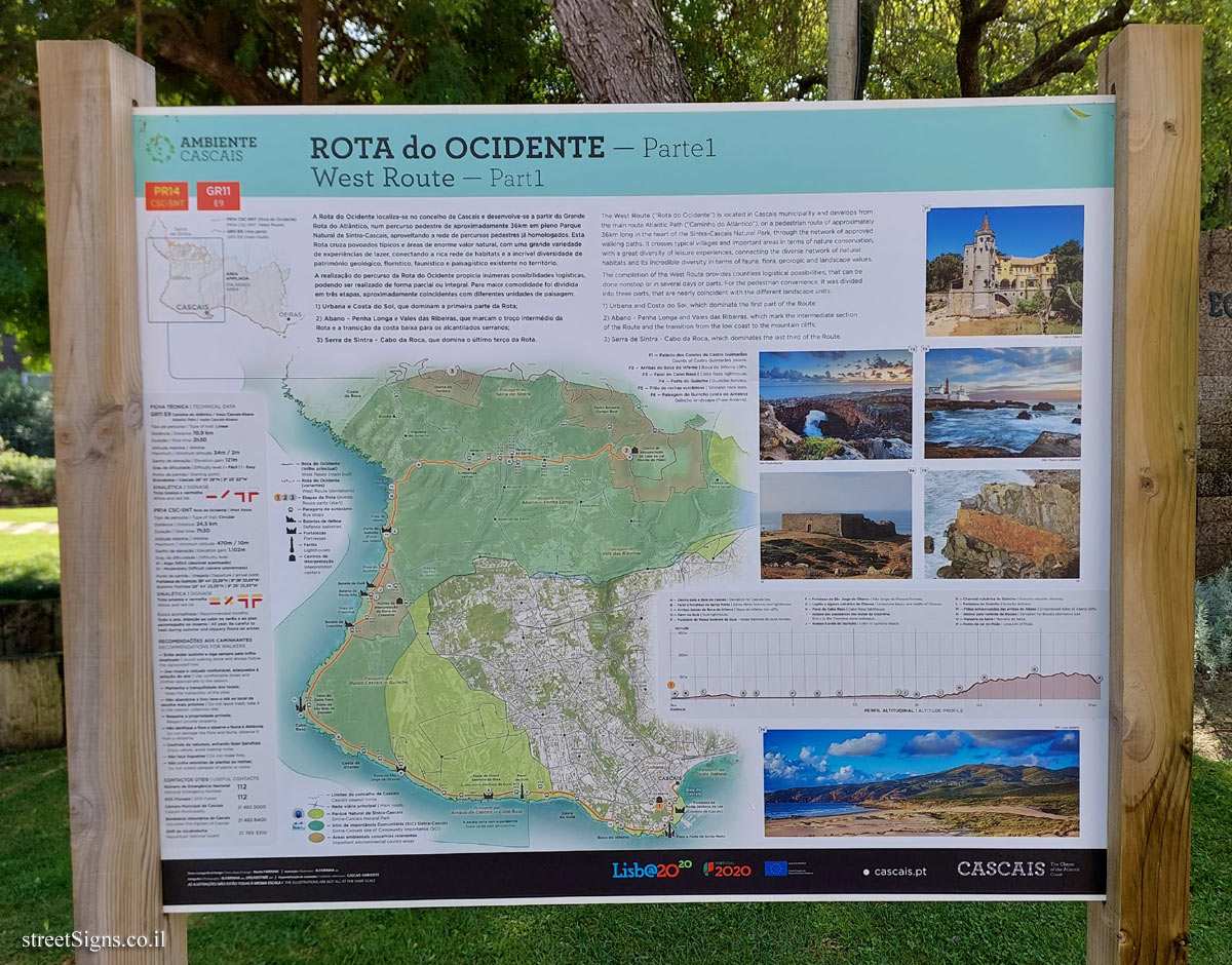
ROTA do OCIDENTE - Parte1
West Route - Part1 A Rota do Ocidente localiza-se no concelho de Cascais e desenvolve-se a partir da Grande Rota do Atlântico, num percurso pedestre de aproximadamente 36km em pleno Parque Natural de Sintra-Cascais, aproveitando a rede de percursos pedestres já homologados. Esta Rota cruza povoados típicos e áreas de enorme valor natural, com uma grande variedade de experiências de lazer, conectando a rica rede de habitats e a incrível diversidade de património geológico, florístico, faunístico e paisagístico existente no território.
A realização do percurso da Rota do Ocidente propicia inúmeras possibilidades logísticas, podendo ser realizado de forma parcial ou integral. Para maior comodidade foi dividida em três etapas, aproximadamente coincidentes com diferentes unidades de paisagem:
1) Urbana e Costa do Sol, que dominam a primeira parte da Rota;
2) Abano - Penha Longa e Vales das Ribeiras, que marcam o troço intermédio da Rota e a transição da costa baixa para os alcantilados serranos;
3) Serra de Sintra Cabo da Roca, que domina o último terço da Rota.
The West Route ("Rota do Ocidente") is located in Cascais municipality and develops from the main route Atlantic Path ("Caminho do Atlántico"), on a pedestrian route of approximately 36km long in the heart of the Sintra-Cascais Natural Park, through the network of approved walking paths. It crosses typical villages and important areas in terms of nature conservation, with a great diversity of leisure experiences, connecting the diverse network of natural habitats and its incredible diversity in terms of fauna, flora, geologic and landscape values.
The completion of the West Route provides countless logistical possibilities, that can be done nonstop or in several days or parts. For the pedestrian convenience, it was divided into three parts, that are nearly coincident with the different landscape units:
1) Urbana and Costa do Sol, which dominate the first part of the Route;
2) Abano - Penha Longa and Vales das Ribeiras, which mark the intermediate section of the Route and the transition from the low coast to the mountain cliffs;
3) Serra de Sintra - Cabo da Roca, which dominates the last third of the Route.
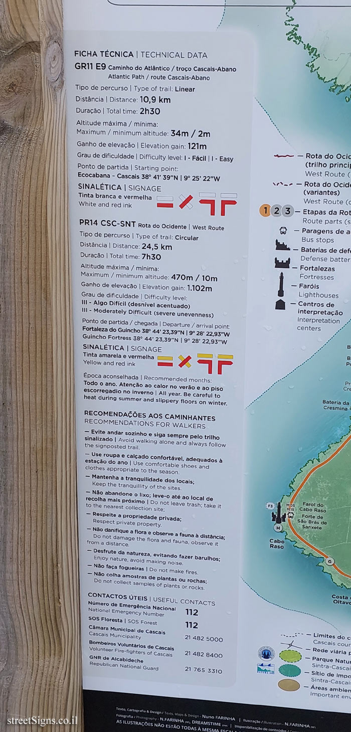
FICHA TÉCNICA | TECHNICAL DATA
GR11 E9 Caminho do Atlântico / troço Cascais-Abano
Atlantic Path/route Cascais-Abano
Tipo de percurso | Type of trail: Linear
Distância | Distance: 10,9 km
Duração | Total time: 2h30
Altitude máxima / mínima:
Maximum / minimum altitude: 34m / 2m
Ganho de elevação | Elevation gain: 121m
Grau de dificuldade | Difficulty level: 1 - Fácil | 1 - Easy
Ponto de partida | Starting point:
Ecocabana - Cascais 38° 41’ 39"N | 9° 25’ 22"W
SINALÉTICA | SIGNAGE
Tinta branca e vermelha
White and red ink
PR14 CSC-SNT Rota do Ocidente | West Route
Tipo de percurso | Type of trail: Circular
Distância | Distance: 24,5 km
Duração | Total time: 7h30
Altitude máxima / mínima:
Maximum / minimum altitude: 470m / 10m
Ganho de elevação | Elevation gain: 1.102m
Grau de dificuldade | Difficulty level:
III- Algo Difícil (desnível acentuado)
III- Moderately Difficult (severe unevenness)
Ponto de partida / chegada | Departure/arrival point:
Fortaleza do Guincho 38° 44’ 23,39"N | 9° 28’ 22,93"W
Guincho Fortress 38° 44’ 23,39"N | 9° 28’ 22,93"W
SINALÉTICA | SIGNAGE
Tinta amarela e vermelha
Yellow and red ink
Época aconselhada | Recommended months:
Todo o ano. Atenção ao calor no verão e ao piso escorregadio no inverno | All year. Be careful to heat during summer and slippery floors on winter.
RECOMENDAÇÕES AOS CAMINHANTES
RECOMMENDATIONS FOR WALKERS
- Evite andar sozinho e siga sempre pelo trilho sinalizado | Avoid walking alone and always follow the signposted trail.
- Use roupa e calçado confortável, adequados à estação do ano | Use comfortable shoes and clothes appropriate to the season.
- Mantenha a tranquilidade dos locais; Keep the tranquillity of the sites.
- Não abandone o lixo; leve-o até ao local de recolha mais próximo | Do not leave trash; take it to the nearest collection site;
- Respeite a propriedade privada; Respect private property.
-Não danifique a flora e observe a fauna à distância; Do not damage the flora and fauna, observe it from a distance.
- Desfrute da natureza, evitando fazer barulhos; Enjoy nature, avoid making noise.
-Não faça fogueiras | Do not make fires.
- Não colha amostras de plantas ou rochas; Do not collect samples of plants or rocks.
CONTACTOS ÚTEIS | USEFUL CONTACTS
Número de Emergência Nacional
National Emergency Number 112
SOS Floresta | SOS Forest 112
Câmara Municipal de Cascais
Cascais Municipality 21 482 5000
Bombeiros Voluntários de Cascais Volunteer
Fire-fighters of Cascais 21 482 8400
GNR de Alcabideche
Republican National Guard 21 765 3310
[The route map]
[Photos from the track]
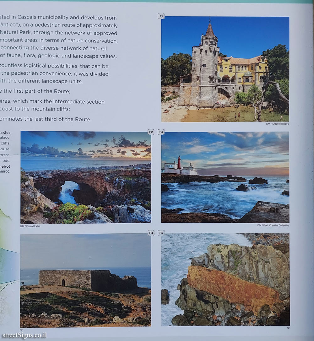
F1-Palácio dos Condes de Castro Guimarães
Counts of Castro Guimarães palace.
F2- Arribas da Boca do Inferno | Boca do Inferno cliffs.
F3 - Farol do Cabo Raso | Cabo Raso lighthouse.
F4 Forte do Guincho | Guincho fortress.
F5 - Filão de rochas vulcânicas | Volcanic rock lode.
F6 Paisagem do Guincho (vista de Arneiro) Guincho landscape (from Arneiro)
[PERFIL ALTITUDINAL | ALTITUDE PROFILE]
EU flag
CASCAIS
The Charm of the Atlantic Coast
cascais.pt


 Click for a larger image
 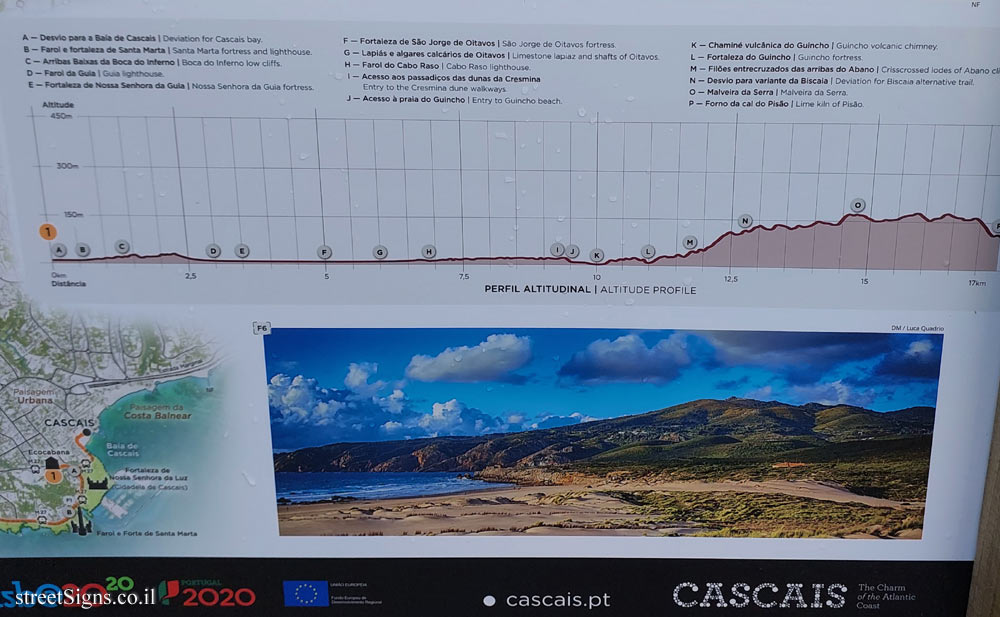 Click for a larger image
 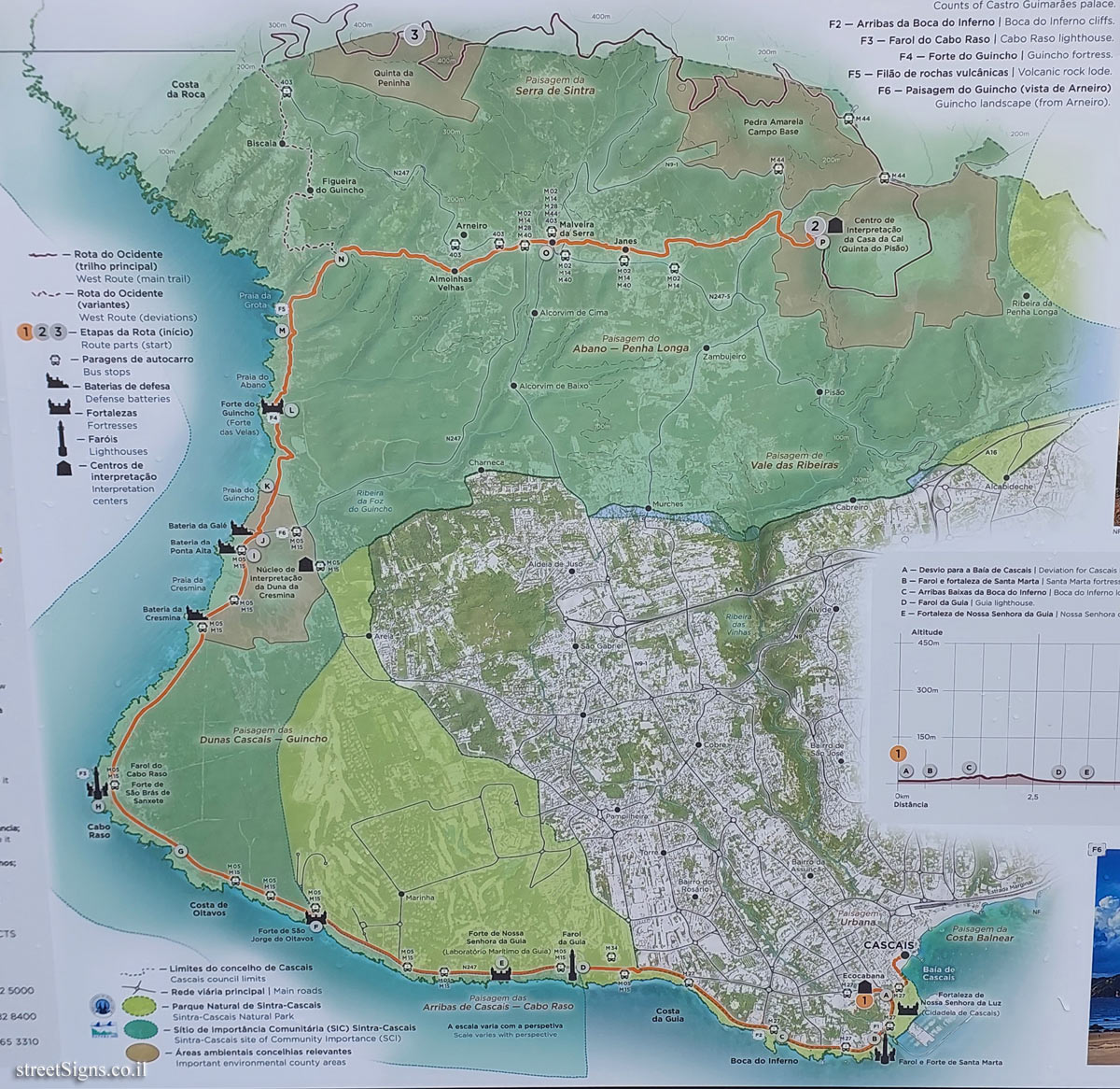 Click for a larger image