Various signs
The ultimate street signs, historical sites and house numbers
× Want to add signs? There is an app! Get it on Google Play Download on the App Store

Sign: Lachish Training Base - A view of the Hebron mountains


Address:
Lakhish, Israel
Category:
Country:
Shape:
Material:
Placement:
Click here for a map that contains other items in the area

On the sign:
[סמל צבא הגנה לישראל]
[סמל מדרשת הדרום]

תצפית על הרי חברון
מהנקודה בה אתם נמצאים ניתן לראות בעיניים את החיבור בין השפלה לשדרת ההר המרכזי. חלק ההר הגבוהה שמולכם נקרא הר חברון. הוא נקרא כך על שם חברון העיר הגדולה והמרכזית הנמצאת באזור.

בימי קדם עברה לאורך ההר הדרך הראשית הנקראת "דרך ההר" (היום "כביש 60"). אם תמשיכו עם "דרך ההר" צפונה תוכלו להגיע עד בואכה ג’נין, ואם תרדו דרומה, תוכלו להגיע עד באר שבע..
מדרום להר חברון נמצא הנגב המנוגב ממים ועל כן שמו. וממזרח אליו נמצא מדבר יהודה, שקיבל את שמו משום סמיכותו להרי יהודה. הרי יהודה והרי חברון הם חלק משדרת ההר המרכזית.

העיר חברון נזכרת בתנ"ך בפעם הראשונה בעת קניין מערת המכפלה על ידי אברהם אבינו לשם קבורת שרה אשתו:
וְאַחֲרֵי-כֵן קָבַר אַבְרָהָם אֶת-שָׂרָה אִשְׁתּוֹ, אֶל-מְעָרַת שְׂדֵה הַמַּכְפֵּלָה עַל-פְּנֵי מַמְרֵא--הִוא חֶבְרוֹן: בְּאֶרֶץ, כְּנָעַן. (בראשית כ"ג, י"ט)

כבר מימי יהושע בן נון מתועדת התיישבות יהודית בהרי חברון.
וַיִּהְיוּ הֶעָרִים, מִקְצֵה לְמַטֵּה בְנֵי-יְהוּדָה, אֶל-גְּבוּל אֱדוֹם, בַּנֶּגְבָּה-... זִיף וָטֶלֶם, וּבְעָלוֹת.(יהושוע ט"ו, כ"א).

גם בימי הבית השני הייתה התיישבות יהודית בהר חברון ואם תבקרו בסוסיא הקדומה תוכלו לראות את ממצאי בית הכנסת המרשימים שבנו היהודים.
לאחר הכיבוש המוסלמי הוקמו כפרים ערביים רבים, אותם אפשר לראות מכאן. ביניהם חלחול, בית עווא, אדנא, דורא, ועוד.

(היישוב נטע על רקע הרי חברון, צילום איתמר חברוני)
Photography:
Add comments, corrections, or missing information. After clicking the "Submit" button you will be taken to a page where you will be required to specify your name and email address.
Please note, you do not need to specify details about the item, these details will be automatically added


Comments:
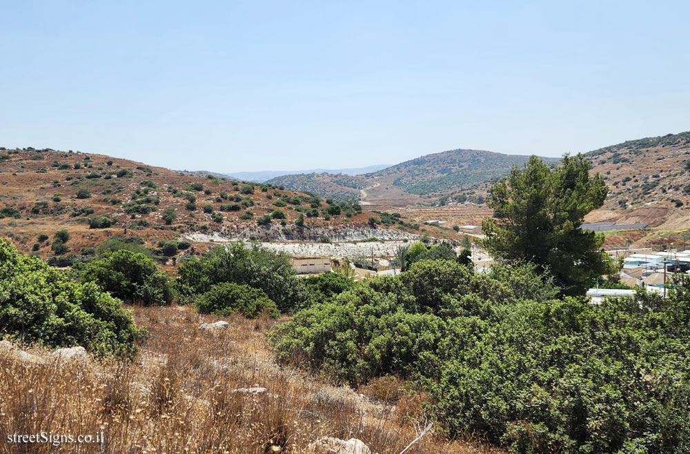
The area where the sign is located with a view of Mount Hebron was photographed on the same day by the same photographer Click for a larger image

Translation of the text on the sign:
[Israel Defense Forces Symbol]
[Symbol of the Midrasha of the South]

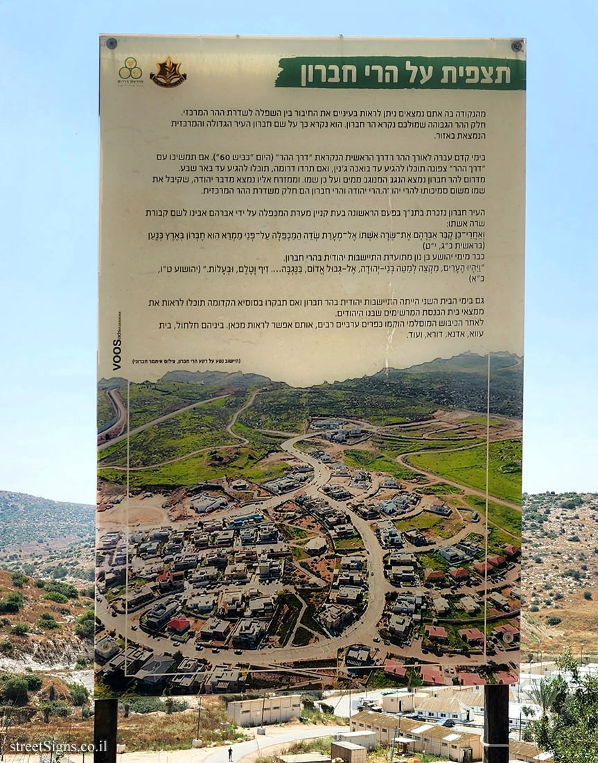
A view of the Hebron mountains
From the point where you are, you can see with your eyes the connection between the lowlands and the central mountain avenue. The part of the high mountain in front of you is called Mount Hebron. It is named after Hebron, the largest and most central city in the region.

In ancient times, the main road called the "Mountain Road" ran along the mountain (today "Road 60"). If you continue with the "Mountain Road" to the north, you can reach the entrances of Jenin, and if you go down to the south, you can reach Beer Sheva.
To the south of Mount Hebron is the Negev, which is wiped with water, hence its name. And to the east of it is the Judean Desert, which got its name because of its proximity to the Judean Mountains. The Yehuda and Hebron mountains are part of the central mountain avenue.

The city of Hebron is mentioned in the Bible for the first time during the acquisition of the Cave of the Patriarchs by Avraham Avino for the burial of his wife Sarah:
And after this, Abraham buried Sarah his wife in the cave of the field of Machpelah before Mamre--the same is Hebron--in the land of Canaan. (Genesis 23:19)

Already from the days of Yehoshua ben Nun there is a documented Jewish settlement in the Hebron mountains.
And the cities at the uttermost part of the tribe of the children of Judah toward the border of Edom in the South ... Ziph, and Telem, and Bealoth (Joshua 15:21).

Even in the days of the Second Temple, there was a Jewish settlement on Mount Hebron, and if you visit the ancient Susya, you will be able to see the impressive findings of the synagogue built by the Jews.
After the Muslim conquest, many Arab villages were established, which can be seen from here. Among them Halhol, Beit Awa, Adna, Dora, and more.

(The settlement named Neta against the background of the Hebron mountains, photo by Itamar Hebroni)


The ultimate street signs, historical sites and house numbers

Initiating the site - Eli Zvuluny - Programming and building the site Possible Worlds Ltd. Possible Worlds Ltd. © 2019-2024

© ALL RIGHTS RESERVED - The site and its content are copyright protected. The full copyrights of the site's content belong to Eli Zvuluny. All images in the site (unless another photographer is mentioned) were taken by Eli Zvuluny that has the full copyrights on them. The use of any images or other materials included herein, in whole or part, for any purpose is expressly prohibited without the written permission of Eli Zvuluny. .