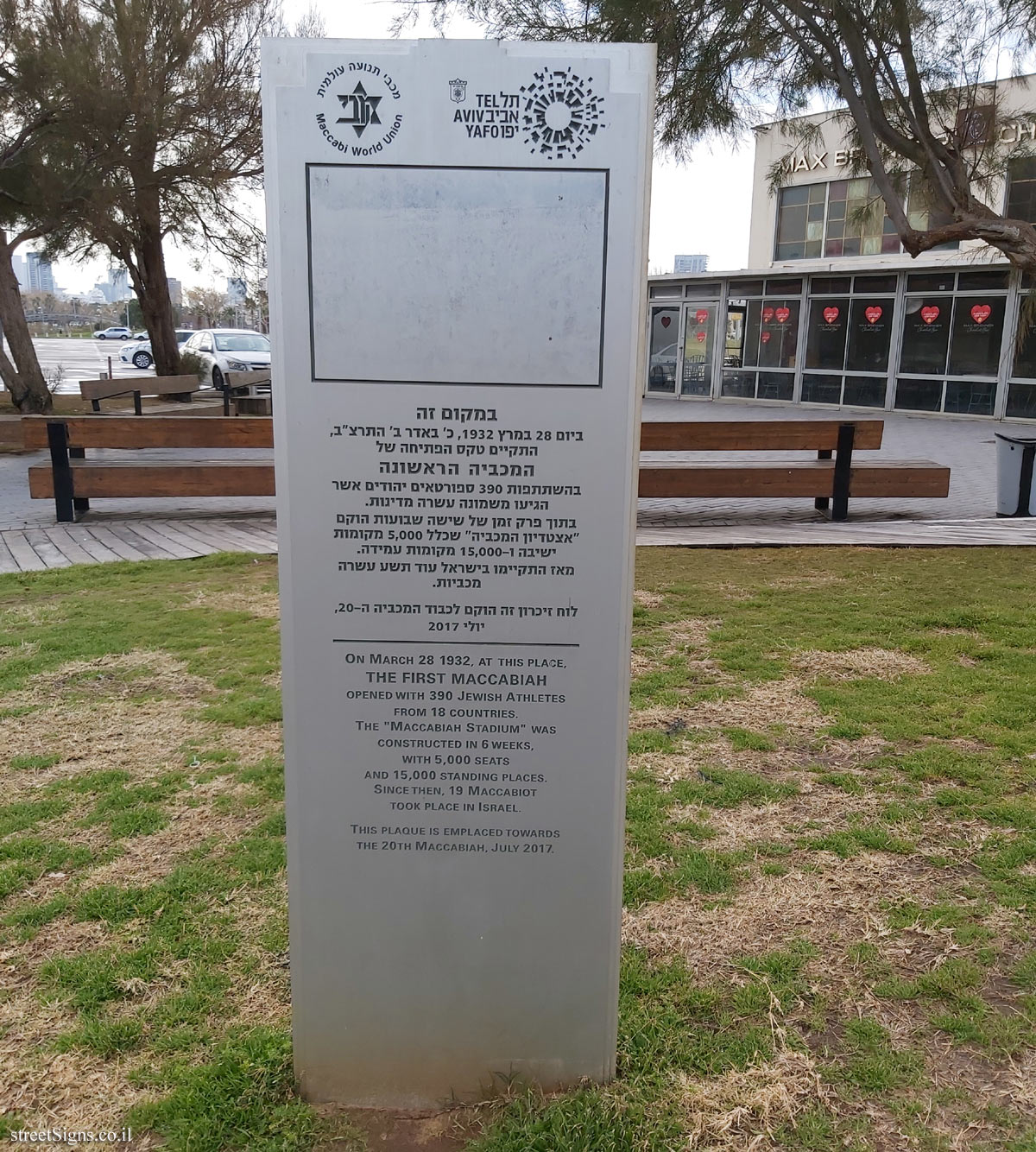
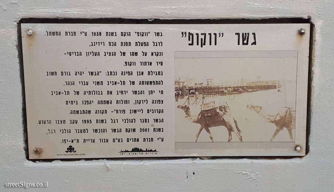
On the sign:
[השלט הימני]
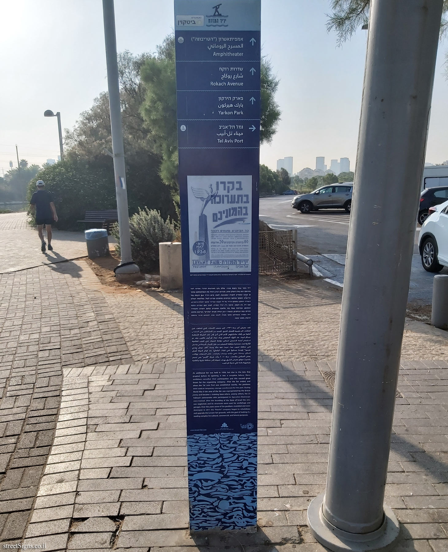
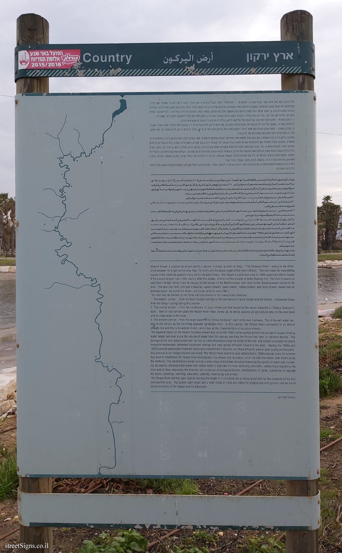
ארץ ירקון
נחל הירקון הוא נחל איתן אשר נקרא בערבית "אלעוג’א" - "הפתלתל", לאור ההבדל בין אורכו בקו אווירי (14.5 ק"מ) לאורכו האמיתי (28 ק"מ). פתלתלותו של הנחל נובעת מהשיפוע המתון בו זורמים המים. שטח אגן ההיקוות של הירקון הינו 1800 קמ"ר והינו הנחל השני בארץ אחרי הירדן, מבחינת כמויות המים הזורמים בו. מקור הנחל הינו בסמוך לראש העין והשפך שלו בים התיכון, נמצא בסמוך לתחנת כח רדינג בתל אביב. לנחל ארבעה יובלים עיקריים: נחל איילון, נחל קנה, נחל רבה ונחל שילה. כמחצית מאגן הניקוז בתחוםהקו הירוק. ניתן לחלק את הנחל לשלושה חלקים לפי מאפייניו:
1. החלק המזרחי - ממעיינות ראש העין ועד לשפך של נחל קנה לירקון. בחלק זה זורמים מים שפירים ממעיינות הירקון.
2. החלק המרכזי - משפח נחל קנה לירקון ועד סכר שבע טחנות. עמק צר, שבו זורם הירקון לאיטו, בפיתולים דרך שטח חקלאי במזרח ושטח עירוני במערב.
3. החלק המערבי - מסכר שבע טחנות ועד שפך הנחל. הקטע המלוח של הירקון אליו חודרים מי ים. בחלק זה זורם הירקון לכיוון מערב בקו ישר כמעט. חלק זה הוא הרחב ביותר והוא בעל מאפיינים של נחל עירוני.
הפגיעה בירקון ניכרת החל משנות ה-50 בהם החלו לשאוב ממי המעיינות לטובת אספקת מי שתייה. מאז כמות מי המעיינות המגיעה לירקון נמצאת בירידה מתמדת. הפגיעה בנחל החמירה עם התפתחות הערים לאורך הנחל, הביאה לכך שבנחל זרמו בעבר שפכים תעשייתיים, שפכים ביתיים גולמיים וקולחים באיכות ירודה. לקראת שנות ה- 60-70 הוקמו באזור מתקנים לטפול בשפכים, אולם הקולחים היו באיכות ירודה, ותהליך זיהום ערוץ הירקון נמשך. רשות נחל הירקון הוקמה בשנת 1988 ועוסקת מאז בשיקום נחל הירקון והכשרתו לפנאי ונופש על פי תכנית אב שהכינה. פעולות השיקום כוללות מגוון פעילויות לשיפור איכות וכמות המים, הזרמת מי קידוחים שפירים לנחל, הוצאת מזהמים, הסדרה הידראולית של הנחל, שיפור המגוון והשפע הביולוגי, פיתוח פארקים, פעילות הסדרת גדות, נטיעות, תכנון, חינוך, הסברה, ניטור ועוד.
נחל הירקון והשטח הפתוח שלאורכו, מהווה את הריאה הירוקה העיקרית לתושבי גוש דן. לאורך הירקון ויובליו שטחים פתוחים איכותיים ומגוון שבילי הולכי רגל ורוכבי אופניים.
[علامة اليمين]
أرض اليركونן
ههردقه للجري النويسمى باللغة العربية نهرالعجا " على ضو الفرق بين طوله بخط جوي (١٤.٥ اكم ) وطوله الخفيفياكم (٢٨ اكم) ينبع العوجاج النهر حر الاحمر العمل النوخري فيلتمسفحضر التجمع للمركز ١٨٠٠ اكيلومترمربع وعنبرالنهرالثقيفي البلايعننهرالاردرمننحيف كميفاللتيجري فيه معلمهرفربريتر هيزمصنعي البحر الأبيض المتوسط الوجودفريب من محطفتولبالطاقة الكهربتبفرين في تل أبيب للنهرأبعفرواغفرنسيق تهرايلون نهركانهررفلينهرشبلونصفححر التصريففي مجال الخط الأخضر يمكن تقسيم النهراليثرثة أقسام حسب ميزانه
١. القسم الشرقي مرسليع روتر معين حتى مصب نهركهافي اليركون ، خري في هذا القسم ميامتازقمنمنبع البركون القسم المركزي مرمصنهركقافي البركوز وحنرجسرشيفطحنون
٢. والوضيق التويجري فيه اليركون ببطء في إعوجاج عن طريق مساحات زراعية في الشرق ومساحاتمني في العرب | القسم الغربي - مرجسرشنع طحنونحن مصب النهر
٣. الجزء المالح من البركونننغلغل فيه مياه البحر لجرى نهر اليركون في هذا الجزء ياخد الغرب يخط مستقيم تقرباحالخرشوالأوسع المميزاتهر بلحي بدا الشبه البركين ابتداء من سنوات لخمسين التي بحوفيها سحب الماء من الينابيع المياه الشرب . منذ ذلك الوقت بدأ النقص في كمية اليد التي تصل إلى نهر البركين تفاقم للتر في النهر مع تطور الملح على امتداد النهر الأمر الذي أدى لجريان مياه المجاري والمصانع للنهر ، والمجاري البينية الإجمالية للتدفقة بنوعية منخفضة جحا . أقيمت في الستينات والسبعينات منسقتنعالجة مياه المجاري في النطفة , ولكن البه التفقد كانتينوعية منخفضة جدا , واستمرت عملية تلوث مجرى النهر . أقيمت سلطة نهر اليركون عم ۱۹۸ نعمل منذ ذلك الوقت بصلاح نهر اليركون وتهيئتمايكون مكنالفضاء الوقت والاستجمام حسب خطة رئيسية التي حضرنها ، تشمل عمليات الإصلاح تشكيلة من العمليات لتحسين جودة وكمية للباد . اسالمياه تنفيبية ممتازة للنهر إخراج موادملة وترتيبات حركة المللنهر حسين تشكيلة المواد الأحيانية البيولوجية تطوير مساحات خضراء عملية ترتيب ضفة النهر زراعة وغرس نبتات تخطيطرتثقيف وتعليم حملاعية فشن حراسفوغيرذلك يعتبرنهر اليركون والسافة الفتحفعل إمتداده , الرنة الخضراء الروسية لسكان منطقة غوش دان . هناك على امتداد نهر اليركون وروافده مساحت مفتوحة ذات جودة وشكبلدرع للمشاوراكبي الدراجات
[The right sign]
Yarkon Country
Stream Yarqon is a perennial stream which is known in Arabic as Nahar el-’Auga - "The Tortuous River" - owing to the difference between its length as the crow flies (14.5 km) and the actual length of the river (28 km). The river owes its meandening nature to the moderate gradient along which the water flows. The Yargon’s catchment area is 1,800 square km which mates it the second largest river in the country after the Jordan, in terms of the volume of water flowing in it. The river’s source is near Rosh Ha’Ayin while it has its estuary on the shores of the Mediterranean Sea ciose to the Reading power station in Tel Aviv. The river has three principal tributaries. Avalon stream. Qana stream. Rabba stream, and Shilo stream. About half its drainage basin lies within the Green Line (Israel prior to June 1967).
The river may be divided up into three sections based on its characteristic features:
1. The eastern section - from the Rosh Ha’Ayin springs to the confluence of Qana stream and the Yarqon. Freshiwater flows trom the Yarqon Springs along this section.
2. The central section - from the confluence of Qana stream and the Yarqon to the seven watermill’s ("Sheva Tachanot") dam. Here in this narrow valley the Yarqon River flows slowly, as its bends passing an agricultural area on the east bank and an urban area on the west.
3. The western section - from the seven watermill’s ("Sheva Tachanot") dam to the river’s estuary. This is the salt-water section of the Yarqon as the incoming seawater penetrates here. In this section, the Yarqon flows westwards in an almost straight line and this is its widest stretch, which has all the characteristics of an urban stream.
The negative impact on the Yarqon has been evident ever since the 1950’s when pumping from the springs to supply drinking water began and ever since the volume of water from the springs reaching the Yarqon has been in constant decline. The damage to the river deteriorated even further as cities developed along the banks of the river and created a situation in which industrial wastewater, untreated household sewage and poor quality effluents flowed in the past. During the 1960s and 1970s several wastewater treatment plants were established in the area, but those effluents were of poor quality and the pollution process in the Yarqon channel continued. The Yarqon River Authority was established in 1988 and ever since its function has been to rehabilitate the Yarqon River and prepare it for leisure and recreation, all in line with the master plan drawn up by the Authority. The rehabilitation works include a wide range of activities aimed at improving the quality of water and increasing its volume, allowing fresh water from drilled wells to flow into the river, removing pollutants, hydraulically regulating the river and its flow, improving the diversity and profusion of biological factors, development of parks, operations to regulate the banks, plantings, planning, education, publicity, monitoring and similar.
The Yarqon River and the open spaces running the length of it constitute the principal green belt tor the residents of the Dan metropolitan area. Top quality open areas and a wide range of trails and paths for pedestrians and cycists can be found along the banks of the Yarqon and its tributaries
[השלט השמאלי]
ארץ הירקון
שפך נחל הירקון
מידע כללי ואתרים חשובים
שפך נחל הירקון הינו נקודת המוצא של נחל הירקון לים. מהים חודרים מים לנחל כתוצאה מהפרשי הגובה בין פני הים לקרקעית הנחל. השפך נמצא בנקודה המערבית ביותר של הירקון, ובסמיכות אל אתרים היסטוריים חשובים כגון תל כודאדי ותל קסילה, כמו גם אתרי פנאי ונופש ומוסדות ציבור ותרבות.
מסלולי טיול עיקריים
שביל הנחל
השביל המרכזי העובר לאורך שתי גדות נחל הירקון מהים במערב ועד מבצר אנטיפטריס במזרח. חלקו חופך לשביל ישראל. מאפשר לחוות את הנחל לכל אורכו. השבילים הנוספים מתחברים אליו. מתאים להולכי רגל ורוכבי אופניים. בקטעים מסוימים מותאם למוגבלים. אורך מסלול כ-60 ק"מ (כ-30 ק"מ לכל כיוון). ניתן לקצר ולעשות רק חלק ממנו. רמת קושי: קל-בינוני.
השביל העירוני (שביל הפארק)
שביל מעגלי בתוך הפארק העירוני בתל אביב ורמת גן המשלב אטרקציות שונות לפנאי ונופש. מתאים להולכי רגל, רוכבי אופניים ומוגבלים. אורך מסלול: משתנה, רמת קושי: קל.
שבילי חיבור ישובים
שבילים המחברים בין נחל הירקון לישובים הסמוכים. מתאים בעיקר לרוכבי אופניים, אורך מלסול: משתנה, רמת קושי: קל-בינוני.
שביל תצפיות הירקון ויובליו
שביל העובר לאורך יובלי הירקון ובסמוך לנקודות תצפית חשובות כגון תל גריסה (גבעת נפוליאון) המאפשרות לקבל מבט רחב על ארץ הירקון. מתאים להולכי רגל ורוכבי אופניים. אורך המסלול: משתנה, רמת קושי: קל-בינוני.
[علامة اليسار]
أرض اليركونן
مصب نهر ياركون
معلومات عامة ومواقع هامة
مصب نهر اليركون هو مخرج نهر اليركون للبحر ، تتغلغل المياه من البحر للسهر نتيجة لتباين الارتفاع بين مستوى البحر وقاع النهر . يفع المصب في أقسى نفطة للبركون من جهة الغرب , وقريبا من مواقع أثرية هامة مثل تل كودادي وثل كسيلة ومثل مواقع للنزهة والاستجمام ومؤسسات عامة وشفافية .
معلومات عامة ومواقع هامة
طريق النهر
الطريق المركري الذي يمرّ على إمتداد ضفتي نهر اليركون من البحر لغربا حنى قلعة انقيباتريس شرقا . جزء منه بطابق طريق إسرائيل . يتيح متعة التمتع بالنهر على امتداده انتصل به الطرق الإضافية ، ملائم للمشاة وراكبي الدراجات ، ملائم بجزء منه للمعوقين طول المسار حوالي 10 كيلومترا ( حوالي ۳۰ كيلومترا لكل إخاء ) . يمكن الاختصار والقيام بجزء منه فقط ، مدى الصعوبة : سهل متوسط
الطريق البلدي
طريق دائري داخل البارك البلدي في تل ابيب ورصات غان الذي يجمع بين أنواع من الف سنة وقضاء الوقت والاستجمام . ملائم للمساة راكبي الدراجات والمعوقين . طول المسار مختلف مدى الصعوبة : سهل
طرق وصل بين المستوطنات
طرق الموصلة بين نهر اليركون والمستوطنات المجاورة . ملائم بصورة خاصة لراكبي الدراجات , طول المسار : مختلف , مدى الصعوبة : سهل – متوسط . .
طريق نقاط مراقبة اليركون وروافده
طريق الذي يمر على امتداد روافد اليركون وبقرب نقاط مراق - اسامة مثل تل جريسة هضبة نابليون ) التي تتيح الحصول على رؤية واحدة لأرص اليركون . . ائم للمشاة وراكبي الدراجات . طول المسار : مختلف مدى الصعوبة سهل -
[The left sign]
Yarkon Country
Yarkon River Estuary
General information and important sites
The Yarqon Riiver estuary marks the place where the Yarqon River flows into the sea. Seawater penetrates up the river here because of the differences in elevation between sea level and the bottom of the river. The estuary is situated at the Yarqon’s westernmost point and lies in close proximity to important historic sites such as Tell Kudadi and Tell Qasile, in addition to leisure and recreation sites as well as public and cultural institutions
Principal tour trails
The river trail
This is the main trail which runs the full length of both banks of the River Yarqon from the sea in the west to Antipatris in the east. In some parts this trail and the Israel Trail, running the length of the country, overlap. The trail allows the visitor to experience at first hand the entire length of the river and additional trails that connect with it. The trail is suitable for hikers and cyclists and in some sections physically challenged people can negotiate it too. The trail is 60 km long (30 km in each direction) and the trip may be shortened by walking or cycling along a part of it. The difficulty level is easy to moderate.
The urban trail
This is a circular trail running within the urban park of Tel Aviv and Ramat Gan which incorporates different attractions for leisure and recreation. The trail is suitable for pedestrians, cyclists and the physically challenged. Length of the trails varies; difficulty level: easy.
Trail linking different settlements
These trails connect the Yarqon River with the adjoining settlements. The trails are especially suitable for cyclists. Length of the trails varies; difficulty level: easy to moderate.
Trail with observations points overlooking the Yarqon and its tributaries
This trail passes along the length of the Yarqon’s tributaries and near important observation points such as Tell Gerisa (Napoleon Hill), which afford a wide view of the Yarqon country. The trail is suitable for hikers, pedestrians and cyclists. Length of the trails varies; difficulty level: easy to moderate.


 Click for a larger image
 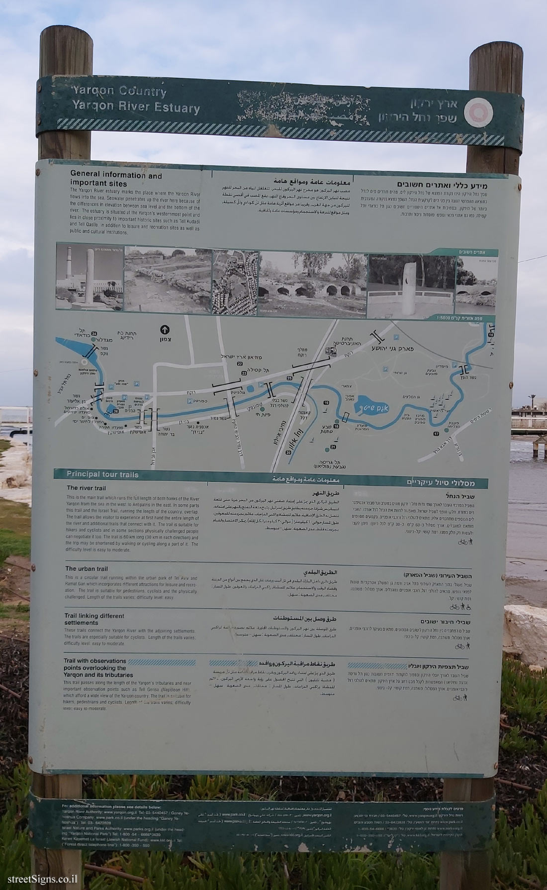 Click for a larger image