Various signs
The ultimate street signs, historical sites and house numbers
× Want to add signs? There is an app! Get it on Google Play Download on the App Store

Sign: Israel National Trail - From Metzudat Yesha (Koach) to Tel Hai

Address:
Israel National Trail, Israel
Category:
Shape:
Material:
Placement:
Click here for a map that contains other items in the area

On the sign:
החברה להגנת הטבע
בשביל ישראל

סמל שביל ישראל
סמל החברה להגנת הטבע

שביל ישראל
ממצודת ישע (כ"ח) לתל חי
From Metzudat Yesha (Koach) to Tel Hai

[מפת השביל]
[Map of the trail]

ברוכים הבאים לקטע שביל ישראל ממצודת ישע לתל חי
עשיתם יופי של דרך! המשיכו צפונה עם השביל!

שביל ישראל נחנך על ידי החברה להגנת הטבע בשנת 1995, במטרה ליצור שביל הליכה רגלי לאורך מדינת ישראל. השביל מתחיל בבית אוסישקין שבקיבוץ דן בצפון ומסתיים בבית ספר שדה אילת של החברה להגנת הטבע, בדרום. שביל ישראל עובר בגליל, בכרמל, לאורך החוף, בתל אביב, ראש העין, שפלת יהודה, מרחב מודיעין, בית גוברין, ביער להב וביער יתיר, בשלושת מכתשי הנגב ולבסוף באילת.
אורכו של שביל ישראל כיום, הוא כ- 1100 ק"מ והוא נבחר לאחד מ-20 שבילי הטיולים הטובים בעולם, על ידי מגזין הנשיונל גיאוגרפיק. שביל ישראל הוא שביל הטיולים הראשון שעלה למפות גוגל סטרייט וויו, שחוצה מדינה שלמה, מתחילתה ועד סופה. את השבילים החדשים ותחזוקת השבילים הקיימים, מבצעים אנשי הוועדה לשבילי ישראל.

תוואי הדרך:
מקטע זה משלב תצפיות נוף ייחודיות על אצבע הגליל, החרמון ושיפולי רמת הגולן, לצד ביקור באתרים היסטוריים שהם נכסי צאן ברזל בהליך תקומתה של ישראל, ממצודת נבי יושע, אנדרטת הארי השואג ובית הקברות בתל חי. בדרכנו נעבור על מצוק רמים, הגבוה במצוקי ישראל, פסגתו מתנשאת לגובה של כ-850 מטר מעל עמק החולה, והוא צופה על הנופים המרהיבים של העמק, הגולן והחרמון. וחוצה לאורכו את רכס הרי נפתלי, שחלקו הצפוני מצוי בשטח לבנון. בתהליך היווצרותו נחשף כאן חלון גיאולוגי נדיר המאפשר הצצה אל מקורם של סלעי משקע יבשתיים וימיים, המונחים זה על גבי זה לפי סדר היווצרותם. מרגלותיו של המצוק הם פארק גיאולוגי ושמורת טבע.

מרחק לשלט הבא: כ-20 קילומטרים

עולם הצומח: עצי אלה אטלנטית, אלת הכלאיים (כלאיים של אלת המסטיק ואלה ארץ-ישראלית) אלון התולע, אלון התבור ואלון מצוי, ??, שקד קטן-עלים, עוזרד קוצני ועוזרד אדום, אירוס נצרתי, כרכום נאה, נזמית מקווקוות וחלמונית זעירה, ומרבדי פריחה של כלניות, רקפות ??

עולם החי: חזיר בר, שועל מצוי ותן זהוב, צבי ארץ ישראלי ושפן הסלע. בעונת הנדידה נבחין בציפורים הנודדות בעמק החולה.

שמירת טבע: מתחתינו בעמק נראה את מעיינות עמק החולה בהם גדלים סוגי צמחי מים נדירים וייחודיים. בגלל חשיבותו [נכלל] עמק החולה ברשימת אתרי הצומח החשובים לשימור של ארגון שמירת הטבע העולמי IUCN שאיבות המים באזור מאיימות לייבש את המעיינות ולהכחיד מינים אלה.

אתרים: מצודת ישע הניצבת בחלק הדרומי של המקטע נקראת על שם הכפר הערבי הסמוך נבי-יושע. בכפר נמצא קבר שייח’ הנביא יושע, המיוחס ליהושע בן נון. המצודה נקראת גם מצודת כ"ח, ע"ש 28 הלוחמים שנהרגו בעת כיבושה במלחמת יום העצמאות, ו-19 מהם קבורים בקבר האחים שמאחוריה. מוזיאון הרעות, שנפתח בסמוך למצודה בראשית 2014, מנציח את הקרבות ואת הלוחמים שנפלו.
פסל הארי השואג של אברהם מלניקוב, הנמצא בבית הקברות שבין תל חי לכפר גלעדי, הוצב בשנת 1934 כמצבת קבר ואנדרטה להרוגים בקרב בתל חי.

היסטוריה: בשנת 1915 הקימה קבוצת חלוצים בגליל העליון את היישוב הקטן תל חי. בי"א באדר (1 במרץ) 1920 התחולל במקום קרב שהפך סמל ללחימת מעטים מול רבים ולחשיבותה של ההתיישבות, ושימש דוגמה לנחישות, לאומץ ולהקרבה. במאורעות בחצר תל חי נהרגו יוסף טרומפלדור ועוד שבעה לוחמים, ושמה של העיר קריית שמונה מנציח את זכרם.

[הטקסט באנגלית ובערבית קשה לקריאה, תרגום של טקסט זה נמצא בגרסה האנגלית של הדף]
[The text in English and Arabic is difficult to read, a translation of this text is in the English version of the page]
Photography:
Add comments, corrections, or missing information. After clicking the "Submit" button you will be taken to a page where you will be required to specify your name and email address.
Please note, you do not need to specify details about the item, these details will be automatically added


Comments:
The shed in which the sign is located was photographed that day by the same photographer 
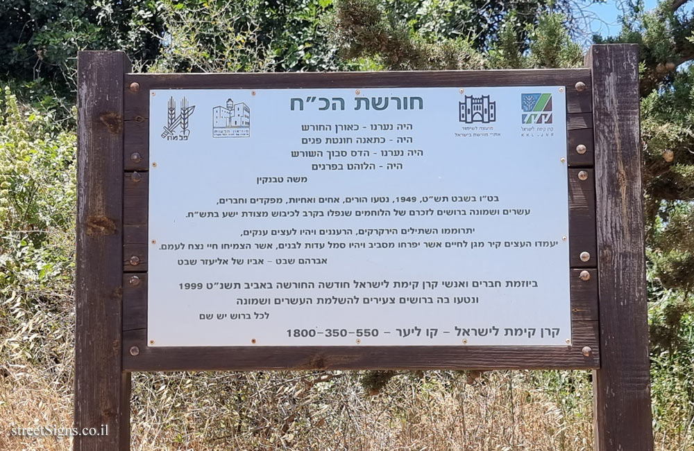
Click for a larger image

Translation of the text on the sign:
[As noted the English text is difficult to read, so the Hebrew text (more detailed) was translated]

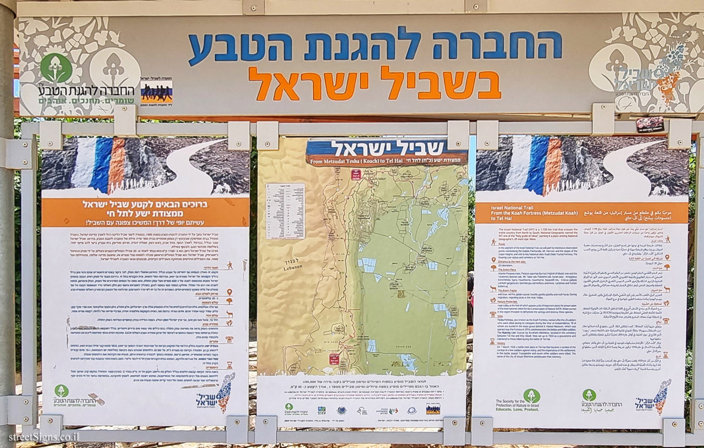
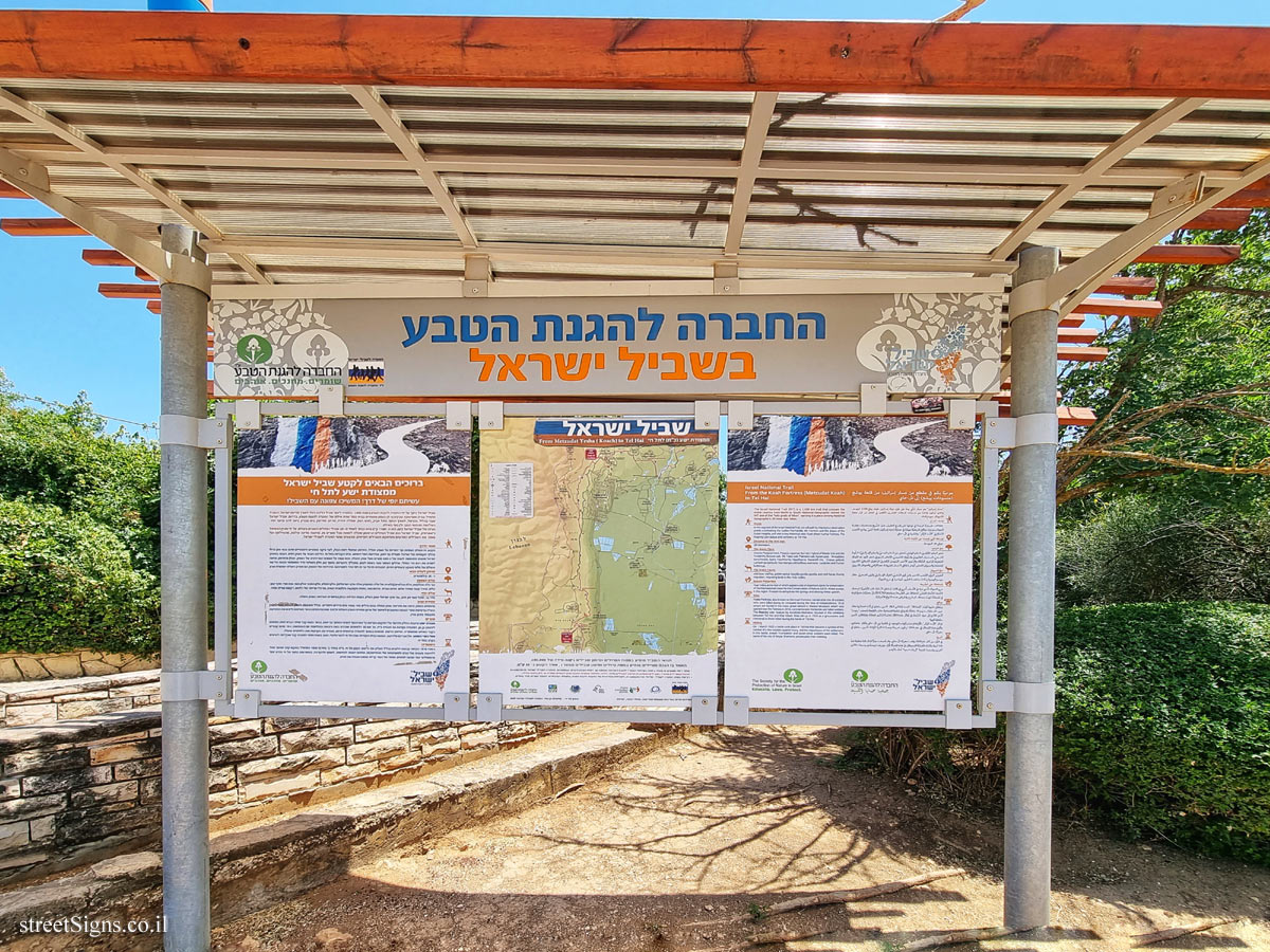
Welcome to the section of the Israel Trail from Yesha Fortress to Tel Hai
You did a beautiful way! Continue north with the trail!

The Israel Trail was inaugurated by the Society for the Protection of Nature in 1995, with the aim of creating a hiking trail along the State of Israel. The trail begins at the Ussishkin House in Kibbutz Dan in the north and ends at the Eilat Field School of the Society for the Protection of Nature, in the south. The Israel Trail passes through the Galilee, the Carmel, along the coast, in Tel Aviv, Rosh HaAyin, the Judean Plain, the Modi’in area, Beit Guvrin, the Lahav forest and the Yatir forest, through the three Negev craters and finally in Eilat.
The length of the Israel Trail today is about 1100 km and it was chosen as one of the 20 best hiking trails in the world, by National Geographic magazine. The new trails and the maintenance of the existing trails are performed by members of the Israel Trails Committee.

The route:
This section combines unique views of the Galilee, Mount Hermon and the slopes of the Golan Heights, along with visits to historical sites that are important assets in the process of Israel’s revival, the Nabi Yehoshua Fortress, the Roaring Lion Monument and the Tel Hai Cemetery. On our way we will pass the "Ramim" cliff, which is the highest in the cliffs of Israel, its summit rises to a height of about 850 meters above the Hula Valley, and it overlooks the spectacular views of the valley, the Golan Heights and Mount Hermon. And crosses along it the Naftali mountain range, the northern part of which is in Lebanese territory. In the process of its formation, a rare geological window was exposed here, which allows a glimpse into the origin of terrestrial and marine sedimentary rocks, which are placed on top of each other in the order in which they were formed. At the foot of the cliff are a geological park and a nature reserve.

Distance to the next sign: about 20 kilometers

The plant world: Pistacia atlantica trees, Pistacia saportae Burnat (hybrids of the Lentisk mastic and erebinth), Aleppo oak, Tabor oak and common oak, ??, small-leaved almond, thorny hawthorn and red hawthorn, Nazareth iris, Crocus pallasii, Lamium garganicum, Sternbergia colchiciflora, and flowering carpets of anemones, cyclamen ??

Wildlife: wild boar, common fox and golden jackal, Eretz Israel deer and rock rabbit. During the migration season we will notice migratory birds in the Hula Valley.

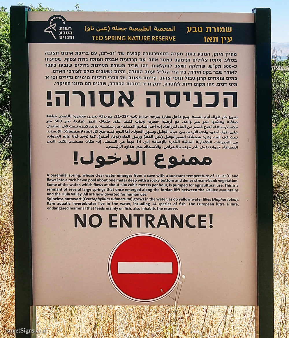
Nature conservation: Below us in the valley we will see the springs of the Hula Valley where rare and unique types of aquatic plants grow. Because of its importance [included] the Hula Valley is on the list of important plant sites for conservation by the IUCN World Conservation Organization Water pumping in the area threatens to dry up the springs and exterminate these species.

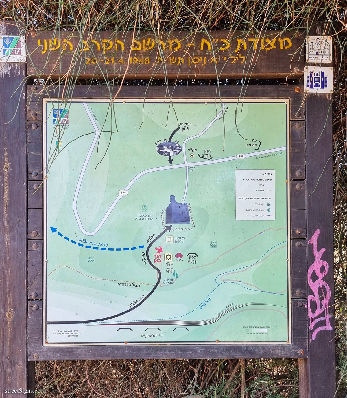
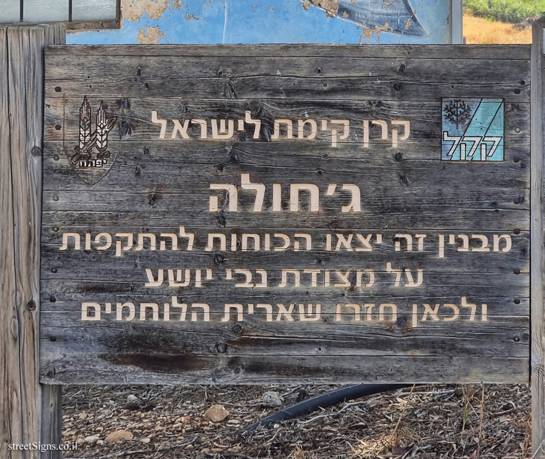
Sites: Yesha Fortress, located in the southern part of the section, is named after the nearby Arab village of Nabi Yoshua. In the village is the tomb of Sheikh the prophet Joshua, attributed to Joshua son of Nun. The fort is also called Fortress Koach, after the 28 warriors who were killed during its conquest during the Independence Day War, and 19 of them are buried in the mass grave behind it. The Reut Museum, which opened near the fort in early 2014, commemorates the battles and fallen warriors.
The roaring lion statue of Avraham Melnikov, located in the cemetery between Tel Hai and Kfar Giladi, was erected in 1934 as a tombstone and monument to those killed in the battle of Tel Hai.

History: In 1915, a group of pioneers in the Upper Galilee established the small settlement of Tel Hai. On Adar 11 (March 1, 1920) a battle took place at the site that became a symbol of the fighting of the few against the many and the importance of settlement, and served as an example of determination, courage and sacrifice.
In the events in the courtyard of Tel Hai, Yosef Trumpeldor and seven other fighters were killed, and the name of the city of Kiryat Shmona perpetuates their memory.

Learn about:


The ultimate street signs, historical sites and house numbers

Initiating the site - Eli Zvuluny - Programming and building the site Possible Worlds Ltd. Possible Worlds Ltd. © 2019-2024

© ALL RIGHTS RESERVED - The site and its content are copyright protected. The full copyrights of the site's content belong to Eli Zvuluny. All images in the site (unless another photographer is mentioned) were taken by Eli Zvuluny that has the full copyrights on them. The use of any images or other materials included herein, in whole or part, for any purpose is expressly prohibited without the written permission of Eli Zvuluny. .