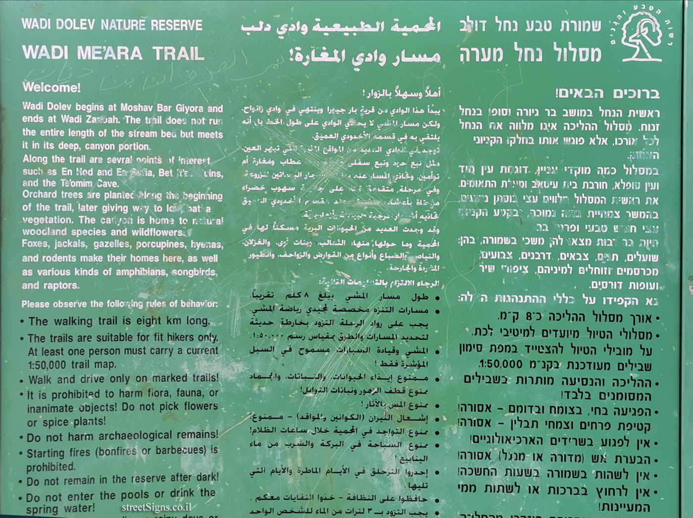
On the sign:
סמל רשות הטבע והגנים
שמורת טבע נחל דולב
מסלול נחל מערה
ברוכים הבאים!
ראשית הנחל במושב בר גיורה וסופו בנחל זנוח. מסלול ההליכה אינו מלווה את הנחל לכל אורכו, אלא פוגש אותו בחלקו הקניוני העמוק.
במסלול כמה מוקדי עניין, דוגמת עין חוד ועין סופלא, חורבת בית עיטאב ומערת התאומים.
את ראשית המסלול מלווים עצי בוסתן נטועים, בהמשך צמחיית בתה נמוכה, ובקע הקניון עצי חורש טבעי ופרחי בר.
חיות בר רבות מצאו להן משכן בשמורה, בהן: שועלים, תנים, צבאים, דרבנים, צבועים, מכרסמים וזוחלים למיניהם, ציפורי שיר ועופות דורסים.
נא הקפידו על כללי ההתנהגות האלה:
• אורך מסלול ההליכה כ-8 ק"מ.
• מסלולי הטיול מיועדים למיטיבי לכת. על מובילי הטיול להצטייד במפת סימון שבילים מעודכנת בקנ"מ 1:50,000.
• ההליכה והנסיעה מותרות בשבילים המסומנים בלבד!
• הפגיעה בחי, בצומח ובדומם - אסורה!
קטיפת פרחים וצמחי תבלין - אסורה!
• אין לפגוע בשרידים הארכיאולוגיים!
• הבערת אש (מדורה או מנגל) אסורה!
• אין לשהות בשמורה בשעות החשכה!
• אין לרחוץ בברכות או לשתות ממי המעיינות!
المحمية الطبيعية وادي دلب
مسار وادي المغار
Symbol of the Nature and Parks Authority
WADI DOLEV NATURE RESERVE
WADI ME’ARA TRAIL
Welcome!
Wadi Dolev begins at Moshav Bar Giyora and ends at Wadi Zanuah. The trail does not run the entire length of the stream bed but meets it in its deep, canyon portion.
Along the trail are sevral points of interest such as En Hod and En Sufla, Beit Eitab ruins, and the Te’omim Cave.
Orchard trees sre planted along the beginhing of the trail, later giving way to low batha vegetation. The canyon is home to natural woodland species and wildflowers.
Foxes, jackals, gazelles, porcupines, hyenas, and rodents make their homes here, as well as various kinds of amphiblans, songbirds, and raptors.
Please observe the folloing rules of behavior:
• The walking trail is eight km long.
• The trails are suitable for fit hikers only. At least one person must carry a current 1:50,000 trail map.
• Walk and drive only on marked trails!
• It is prohibited to harm flora, fauna, or inanimate objects! Do not pick flowers or spice plants!
• Do not harm archaeological remains!
• Starting fires (bonfires or barbecues) is prohibited.
• Do not remain in the reserve after dark!
• Do not enter the pools or drink the spring water!