On the sign:
החברה להגנת הטבע
בשביל ישראל
סמל שביל ישראל
סמל החברה להגנת הטבע
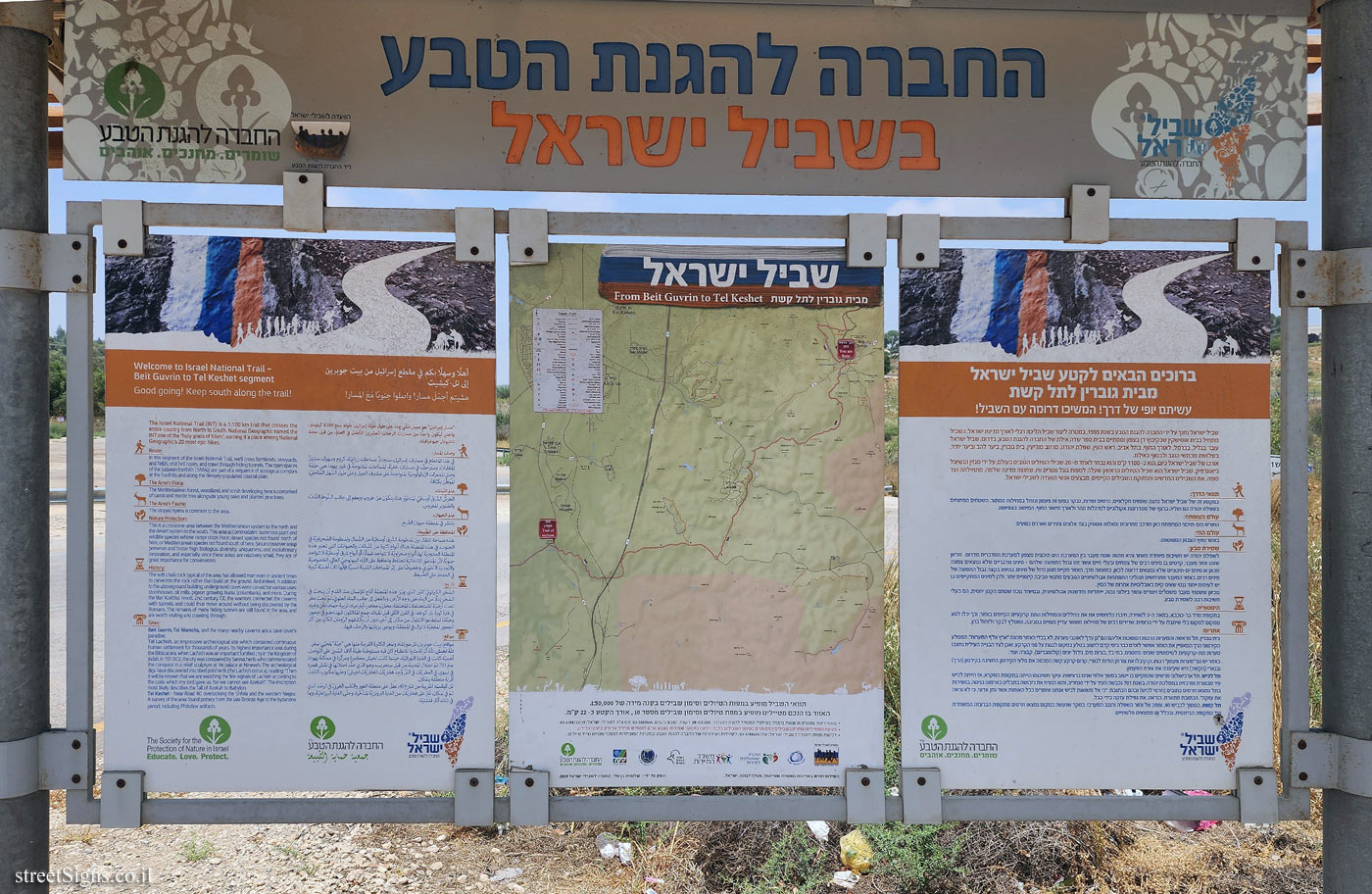
שביל ישראל
מבית גוברין לתל קשת
From Beit Guvrin to Tel Keshet
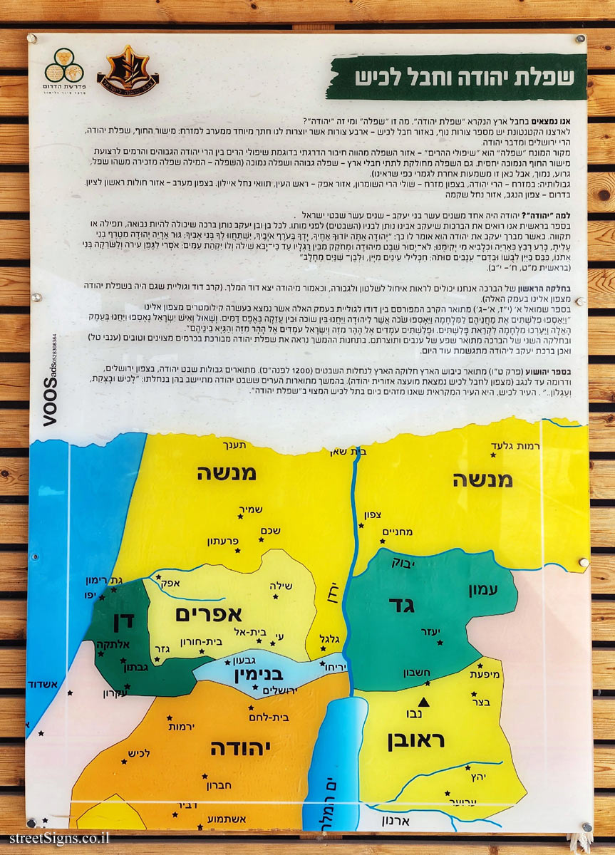
[מפת השביל]
[Map of the trail]
ברוכים הבאים לקטע שביל ישראל מבית גוברין לתל קשת
עשיתם יופי של דרך! המשיכו דרומה עם השביל!
שביל ישראל נחנך על ידי החברה להגנת הטבע בשנת 1995, במטרה ליצור שביל הליכה רגלי לאורך מדינת ישראל. השביל מתחיל בבית אוסישקין שבקיבוץ דן בצפון ומסתיים בבית ספר שדה אילת של החברה להגנת הטבע, בדרום. שביל ישראל עובר בגליל, בכרמל, לאורך החוף, בתל אביב, ראש העין, שפלת יהודה, מרחב מודיעין, בית גוברין, ביער להב וביער יתיר, בשלושת מכתשי הנגב ולבסוף באילת.
אורכו של שביל ישראל כיום, הוא כ- 1100 ק"מ והוא נבחר לאחד מ- 20 שבילי הטיולים הטובים בעולם, על ידי מגזין הנשיונל ג’יאוגרפיק, שביל ישראל הוא שביל הטיולים הראשון שעלה למפות גוגל סטריט וויו, שחוצה מדינה שלמה, מתחילתה ועד סופה. את השבילים החדשים ותחזוקת השבילים הקיימים, מבצעים אנשי הוועדה לשבילי ישראל.
תוואי הדרך:
במקטע זה של שביל ישראל נחצה שטחים חקלאיים, כרמים ושדות, נבקר במערות פעמון ונזחל במחילות מסתור. השטחים הפתוחים בשפלת יהודה הם חוליה ברצף של מסדרונות אקולוגיים למרגלות ההר ולאורך מישור החוף, המיושב בצפיפות.
עולם הצומח:
החורש הים-תיכוני המתפתח כאן מורכב מחרובים ומאלות מסטיק בצד אלונים צעירים ואורנים נטועים.
עולם החי:
באזור נפוץ הצבוע המפוספס.
שמירת טבע:
לשפלת יהודה יש חשיבות מאחר והיא מהווה שטח מעבר בין המערכת הים תיכונית מצפון למערכת המדברית מדרום. מכיוון שזהו אזור מעבר, קיימים בו מינים רבים של צמחים ובעלי חיים אשר זהו גבול התפוצה שלהם - מינים מדבריים שלא נמצאים צפונה מכאן או מינים ים תיכוניים שלא נמצאים דרומה לכאן. כתוצאה מכך, האזור מקיים מגוון גדול של מינים. בהיותו בקצה גבול התפוצה של מינים רבים, באזור המעבר מתרחשים תהליכי התפתחות אבולוציוניים הנובעים מתנאי סביבה קיצוניים יותר, ולכן למינים המתקיימים בו יש לעיתים ייחוד גנטי שאינו קיים באוכלוסיות אחרות של המין
מכיוון ששטחי מעבר משמרים ויוצרים עושר ביולוגי גבוה, ייחודיות וחדשנות אבולוציונית, ובמיוחד נוכח שטחם הקטן יחסית, הם בעלי חשיבות רבה לשמירת טבע.
היסטוריה:
בתקופתםרד בר-כוכבא במאה ה-2 לספירה, חיברו הלוחמים את את החללים והמחילות התת קרקעיים הקיימים באזור, וכך יכלו לנוע ממקום למקום בלי שיתגלו על ידי הרומים. שרידים רבים של מחילות מסתור עדיין מצויים בסביבה, ומומלץ לבקר ולזחול בהן.
אתרים:
בית גוברין, תל מראשה והמערות הרבות הסמוכות אליהם הם ’גן עדן’ לאוהבי מערות. לא בכדי האזור מכונה "ארץ אלף המערות". המסלע הקירטוני הרך המאפיין את האזור אפשר לאדם כבר בימי קדם לחצוב בסלע במקום לבנות על פני הקרקע. ואכן לצד הבנייה העילית נחצבו מערות תת-קרקעיות לשימושים שונים: מחסנים, בתי בד, בורות מים, גידול יונים (קולומבריום), קבורה ועוד.
באזור יש גם "מערות פעמון" רבות. הן קיבלו את צורתן הודות לנארי, קרום קרקע קשה המכסה את סלעי הקירטון. החציבה בקירטון (הרך) ובנארי (הקשה) היא שעיצבה את צורת הפעמון.
תל לכיש, תל ארכיאולוגי מרשים שהתקיים בו יישוב במשך אלפי שנים ברציפות. עיקר חשיבותו הייתה בתקופת המקרא, אז הייתה לכיש עיר מבוצרת ומרכזית בממלכת יהודה. בשנת 701 נכבשה העיר על ידי סנחריב, והוא הנציח את כיבושה בתבלים בארמונו בנינוה. בחפירות בתל נמצאו חרסים כתובים (חרסי לכיש) ובהם הכתובת: "כי אל משואות לכיש אנחנו שומרים ככל האותות אשר נתן אדוני, כי לא נראה את עזקה". הכתובת מתארת, כנראה, את נפילת עזקה בידי בבל.
תל קשת הסמוך לכביש 40, צופה אל אזור השפלה והנגב המערבי. בסקר שנעשה במקום נמצאו חרסים מתקופת הברונזה המאוחרת ועד התקופה הביזנטית, ובכלל זה ממצאים פלשתיים.
[סמל שביל ישראל]
[סמל החברה להגנת הטבע]
[מפת המסלול]
[route map]
أهلًا وسهلا بكم في مقطع إسرائيل من بيت جوبرين إلى تل - كيشيت
مشيتم أجمل مسار واصلوا جنوبا مع المسار!
"مسار إسرائيل" هو مسار مني هند على طول دولة إسرائيل، طوله يبلغ 1100 كيلوم واختير ليكون واحدا من مسارات الرحلات العشرين الأفضل في العالم، من قبل مجلة ناشيونال جيوفر الان
وصف المسار:
في هذا المقطع في مسارات إسرائيل ستجتاز مساحات زراعية كروم وسهوله سنزور المغارات، وسترحت في مسارات خفية، المساحات المفتوحة في غور يهودا هي حلقة في السعرات الإيكولوجية المتواجدة على مشارف الجبل وعلى طول السهل الساحلي الموطن بكثافة.
عالم النبات
الحرس الشرق أوسطي المنطور هنا يتكون من خروب ونظم إلى جانب البلوط الشاب والصنوبر المغروس
عالم الحيوان ينتشر في المنطقة حيوان الطبع.
المحافظة على الطبيعة
هذه مساحة انتقال بين المنظومة الشرق أوسطية من الشمال والمنظومة الصحراوية في الجنوب. في هذه المنطقة هناك أنواع كثيرة من النباتات والحيوانات التي تعتبر هذه المنطقة الحدودية لها، أنواع صحراوية لا تتواجد شمالا، أو أنواع شرق أوسطية لا تتواجد جنوبا. لأن المناطق الانتقالية تحتفظ وتحافظ على الثراء البيولوجي العالي الخصوصية والتجديد التطوري وخصوصا على إثر المساحات القليلة نسيا فإنها ذات أهمية كبيرة في الحفاظ على الطبيعة
تاریخ الصخر الكيرتون التين الذي يميز هذه المنطقة أتاح للإنسان منذ القدم أن ينحت في الصخر بدلا من البناء على وجه الأرض. وبالفعل إلى جانب البناء العلوي تم تحت مغر تحت أرضية للاستخدامات المختلفة مخازن معاصر آبار مياه تربية حمام، دفن و غیره في فترة ثورة بار- كوخفاء في القرن الثاني قبل الميلاد، جمع المقاتلون شهداء هم في جحور وهكذا استطاعوا الانتقال من مكان إلى آخر، دون أن يكشفهم الرومان الكثير من آثار الجحور المخفية لا تزال في المنطقة، ويوصى بزيارتها والزحف فيها.
Welcome to Israel National Trail
Beit Guvrin to Tel Keshet segment
Good going! Keep south along the trail!
The Israel National Trail (INT) is a 1,100 km trail that crosses the entire country from North to South. National Geographic named the INT one of the "holy grails of hikes", earning it a place among National Geographic’s 20 most epic hikes.
Route:
In this segment of the Israel National Trail, we’ll cross farmlands, vineyards, and fields, visit bell caves, and crawl through hiding tunnels. The open spaces of the Judaean foothills (Shfela) are part of a sequence of ecological corridors at the foothills and along the densely populated coastal plain.
The Area’s Flora:
The Mediterranean forest, woodland and scrub developing here is comprised of carob and mastic tree alongside young oaks and planted pine trees.
The Area’s Fauna:
The striped hyena is common to the area
Nature Protection:
This is a crossover area between the Mediterranean system to the north and the desert system to the south. This area accommodates numerous plant and wildlife species whose range stops here: desert species not found north of here, or Mediterranean species not found south of here. Since crossover areas preserve and foster high biological diversity, uniqueness, and evolutionary innovation, and especially since these areas are relatively small they are of great importance for conservation.
History:
The soft chalk rock typical of the area has allowed man even in ancient times to carve into the rock rather than build on the ground. And indeed, in addition to the aboveground building, underground caves were carved for various uses: storehouses, oil mills, pigeon growing burial (columbaria), and more. During the Bar Kokhba revolt 2nd century CE the warriors connected the caverns with tunnels, and could thus move around without being discovered by the Romans. The remains of many hiding tunnels are still found in the area, and are worth visiting and crawling through.
Sites:
Beit Guvrin, Tel Maresha, and the many nearby caverns are a cave-lover’s paradise.
Tel Lachish, an impressive archeological site which contained continuous human settlement for thousands of years. Its highest importance was during the Biblical era, when Lachish was an important fortified city in the Kingdom of Judah. In 701 BCE, the city was conquered by Sennacherib, who commemorated the conquest in a relief sculpture at his palace at Nineveh. The archeological digs have discovered inscribed potsherds (the Lachish ostraca), reading: Then it will be known that we are watching the fire-signals of Lachish according to the code which my lord gave us, for we cannot see Azekah". The inscription most likely describes the fall of Azekah to Babylon.
Tel Keshet - Near Road 40, overlooking the Shfela and the western Negev,
A survey of the area found pottery from the late Bronze Age to the byzantine
penod, including Philistine artifacts.
The Society for the Protection of Nature in Israel
Educate. Love. Protect.
[Symbol of the Israel Trail]


 Click for sign's details
  Click for sign's details
 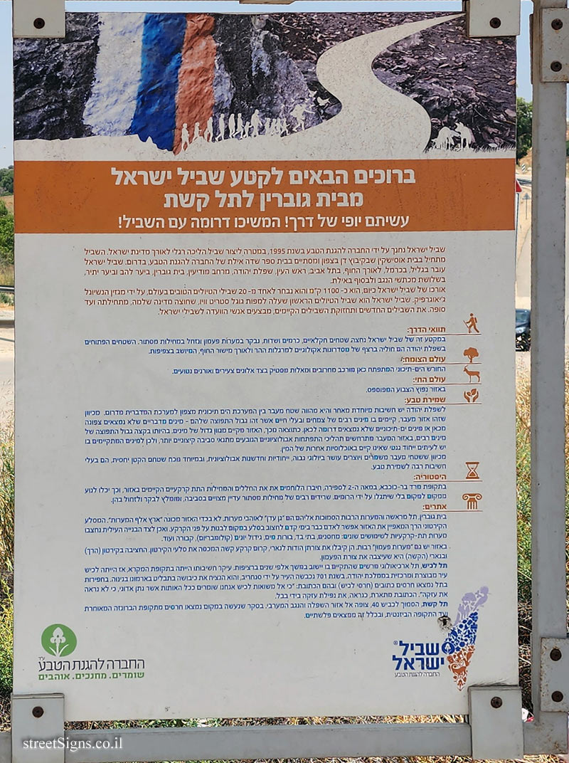 Click for a larger image
 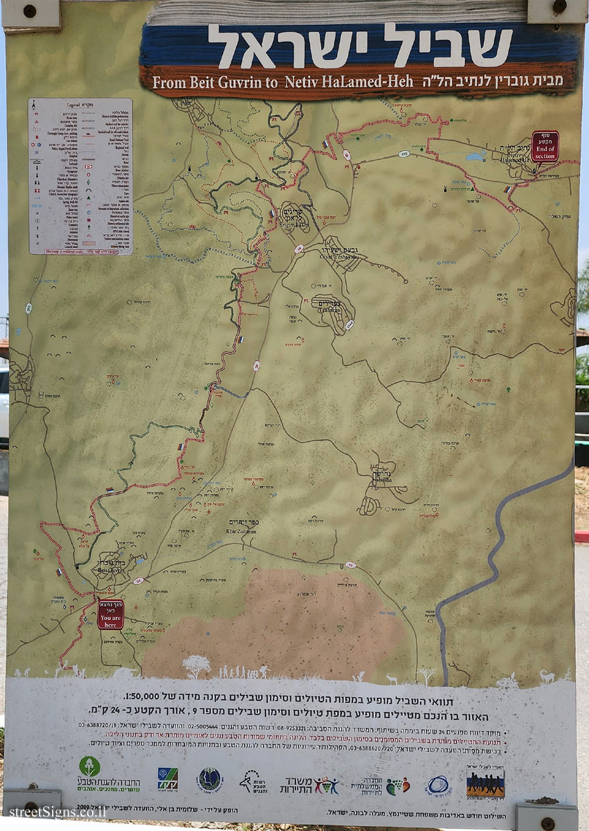 Click for a larger image